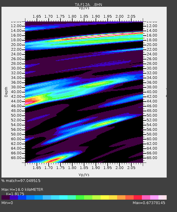
F12A Elk City, ID, USA - Earthquake Result Viewer

Earthquake location: Near West Coast Of Honshu, Japan
Earthquake latitude/longitude: 37.5/138.4
Earthquake time(UTC): 2007/07/16 (197) 01:13:22 GMT
Earthquake Depth: 12 km
Earthquake Magnitude: 6.5 MB, 6.4 MS, 6.6 MW, 6.5 MW
Earthquake Catalog/Contributor: WHDF/NEIC
Network: TA USArray Transportable Network (new EarthScope stations)
Station: F12A Elk City, ID, USA
Lat/Lon: 45.76 N/115.25 W
Elevation: 1442 m
Distance: 73.9 deg
Az: 44.374 deg
Baz: 307.432 deg
Ray Param: 0.052678082
Estimated Moho Depth: 16.0 km
Estimated Crust Vp/Vs: 1.92
Assumed Crust Vp: 6.577 km/s
Estimated Crust Vs: 3.43 km/s
Estimated Crust Poisson's Ratio: 0.31
Radial Match: 97.049515 %
Radial Bump: 400
Transverse Match: 92.347496 %
Transverse Bump: 400
SOD ConfigId: 2564
Insert Time: 2010-03-06 20:38:35.048 +0000
GWidth: 2.5
Max Bumps: 400
Tol: 0.001

Signal To Noise

ChannelStoNSTALTA
TA:F12A: :BHN:20070716T01:24:25.924016Z16.1122576.1646836E-73.8260833E-8
TA:F12A: :BHE:20070716T01:24:25.924016Z18.7184148.175662E-74.3677108E-8
TA:F12A: :BHZ:20070716T01:24:25.924016Z65.418353.0179115E-64.613249E-8
Arrivals
Ps2.3 SECOND
PpPs6.9 SECOND
PsPs/PpSs9.2 SECOND