You are here: Home > Network List > TA - USArray Transportable Network (new EarthScope stations) Stations List
> Station F12A Elk City, ID, USA > Earthquake Result Viewer
F12A Elk City, ID, USA - Earthquake Result Viewer
| Earthquake location: |
Hokkaido, Japan Region |
| Earthquake latitude/longitude: |
43.7/144.7 |
| Earthquake time(UTC): |
2007/07/01 (182) 04:12:07 GMT |
| Earthquake Depth: |
130 km |
| Earthquake Magnitude: |
5.5 MB, 5.8 MW, 5.8 MW |
| Earthquake Catalog/Contributor: |
WHDF/NEIC |
|
| Network: |
TA USArray Transportable Network (new EarthScope stations) |
| Station: |
F12A Elk City, ID, USA |
| Lat/Lon: |
45.76 N/115.25 W |
| Elevation: |
1442 m |
|
| Distance: |
66.2 deg |
| Az: |
48.877 deg |
| Baz: |
308.66 deg |
| Ray Param: |
0.057385065 |
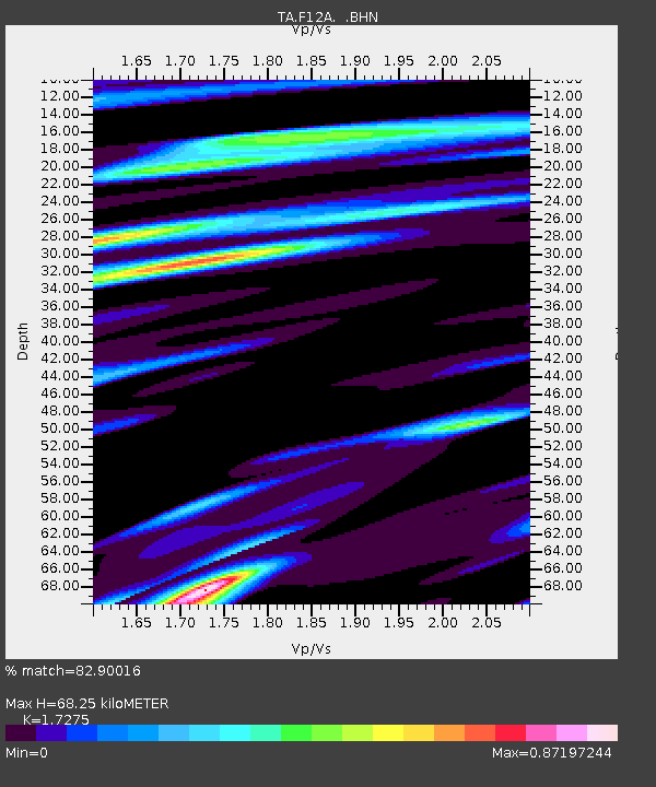
| Estimated Moho Depth: |
68.25 km |
| Estimated Crust Vp/Vs: |
1.73 |
| Assumed Crust Vp: |
6.577 km/s |
| Estimated Crust Vs: |
3.807 km/s |
| Estimated Crust Poisson's Ratio: |
0.25 |
|
| Radial Match: |
82.90016 % |
| Radial Bump: |
400 |
| Transverse Match: |
64.34053 % |
| Transverse Bump: |
400 |
| SOD ConfigId: |
2564 |
| Insert Time: |
2010-03-06 20:38:41.768 +0000 |
| GWidth: |
2.5 |
| Max Bumps: |
400 |
| Tol: |
0.001 |
|

Signal To Noise
| Channel | StoN | STA | LTA |
| TA:F12A: :BHN:20070701T04:22:10.950012Z | 2.4011416 | 9.3384195E-8 | 3.889158E-8 |
| TA:F12A: :BHE:20070701T04:22:10.950012Z | 2.687691 | 1.2087379E-7 | 4.49731E-8 |
| TA:F12A: :BHZ:20070701T04:22:10.950012Z | 7.0364995 | 3.7947464E-7 | 5.3929465E-8 |
| Arrivals |
| Ps | 7.9 SECOND |
| PpPs | 27 SECOND |
| PsPs/PpSs | 35 SECOND |


