You are here: Home > Network List > TA - USArray Transportable Network (new EarthScope stations) Stations List
> Station F12A Elk City, ID, USA > Earthquake Result Viewer
F12A Elk City, ID, USA - Earthquake Result Viewer
| Earthquake location: |
Kamchatka Peninsula, Russia |
| Earthquake latitude/longitude: |
52.1/157.3 |
| Earthquake time(UTC): |
2007/05/30 (150) 20:22:12 GMT |
| Earthquake Depth: |
116 km |
| Earthquake Magnitude: |
6.4 MB, 6.4 MW, 6.4 MW |
| Earthquake Catalog/Contributor: |
WHDF/NEIC |
|
| Network: |
TA USArray Transportable Network (new EarthScope stations) |
| Station: |
F12A Elk City, ID, USA |
| Lat/Lon: |
45.76 N/115.25 W |
| Elevation: |
1442 m |
|
| Distance: |
54.4 deg |
| Az: |
59.282 deg |
| Baz: |
310.814 deg |
| Ray Param: |
0.065079235 |
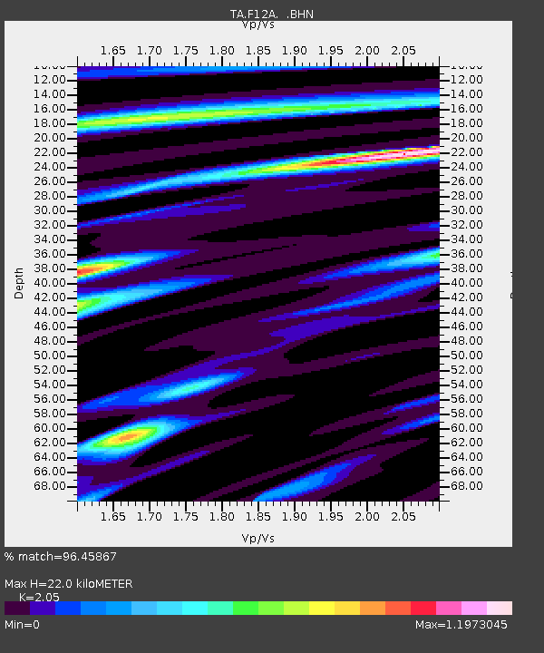
| Estimated Moho Depth: |
22.0 km |
| Estimated Crust Vp/Vs: |
2.05 |
| Assumed Crust Vp: |
6.577 km/s |
| Estimated Crust Vs: |
3.208 km/s |
| Estimated Crust Poisson's Ratio: |
0.34 |
|
| Radial Match: |
96.45867 % |
| Radial Bump: |
367 |
| Transverse Match: |
91.41562 % |
| Transverse Bump: |
400 |
| SOD ConfigId: |
2564 |
| Insert Time: |
2010-03-06 20:38:44.647 +0000 |
| GWidth: |
2.5 |
| Max Bumps: |
400 |
| Tol: |
0.001 |
|

Signal To Noise
| Channel | StoN | STA | LTA |
| TA:F12A: :BHN:20070530T20:30:57.399014Z | 50.928375 | 1.9526024E-6 | 3.8340165E-8 |
| TA:F12A: :BHE:20070530T20:30:57.399014Z | 39.71115 | 2.4080223E-6 | 6.063844E-8 |
| TA:F12A: :BHZ:20070530T20:30:57.399014Z | 80.616455 | 5.5419496E-6 | 6.874465E-8 |
| Arrivals |
| Ps | 3.7 SECOND |
| PpPs | 9.7 SECOND |
| PsPs/PpSs | 13 SECOND |


