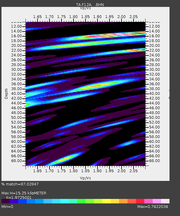
F12A Elk City, ID, USA - Earthquake Result Viewer
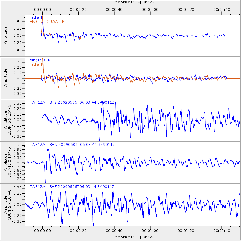
Earthquake location: Near East Coast Of Honshu, Japan
Earthquake latitude/longitude: 35.5/140.9
Earthquake time(UTC): 2009/06/06 (157) 05:52:43 GMT
Earthquake Depth: 34 km
Earthquake Magnitude: 5.8 MB, 5.4 MS, 5.8 MW, 5.7 MW
Earthquake Catalog/Contributor: WHDF/NEIC
Network: TA USArray Transportable Network (new EarthScope stations)
Station: F12A Elk City, ID, USA
Lat/Lon: 45.76 N/115.25 W
Elevation: 1442 m
Distance: 74.0 deg
Az: 45.015 deg
Baz: 304.463 deg
Ray Param: 0.052593082
Estimated Moho Depth: 15.25 km
Estimated Crust Vp/Vs: 1.97
Assumed Crust Vp: 6.577 km/s
Estimated Crust Vs: 3.334 km/s
Estimated Crust Poisson's Ratio: 0.33
Radial Match: 87.02847 %
Radial Bump: 400
Transverse Match: 78.94678 %
Transverse Bump: 400
SOD ConfigId: 2648
Insert Time: 2010-03-06 20:38:59.151 +0000
GWidth: 2.5
Max Bumps: 400
Tol: 0.001

Signal To Noise

ChannelStoNSTALTA
TA:F12A: :BHN:20090606T06:03:44.349011Z18.8018446.624237E-73.5231846E-8
TA:F12A: :BHE:20090606T06:03:44.349011Z3.31437921.2619299E-73.80744E-8
TA:F12A: :BHZ:20090606T06:03:44.349011Z3.88499641.8542765E-74.772917E-8
Arrivals
Ps2.3 SECOND
PpPs6.7 SECOND
PsPs/PpSs9.0 SECOND