You are here: Home > Network List > TA - USArray Transportable Network (new EarthScope stations) Stations List
> Station F12A Elk City, ID, USA > Earthquake Result Viewer
F12A Elk City, ID, USA - Earthquake Result Viewer
| Earthquake location: |
South Of Panama |
| Earthquake latitude/longitude: |
5.7/-82.8 |
| Earthquake time(UTC): |
2009/03/12 (071) 23:23:34 GMT |
| Earthquake Depth: |
9.0 km |
| Earthquake Magnitude: |
6.1 MB, 5.9 MS, 6.3 MW, 6.2 MW |
| Earthquake Catalog/Contributor: |
WHDF/NEIC |
|
| Network: |
TA USArray Transportable Network (new EarthScope stations) |
| Station: |
F12A Elk City, ID, USA |
| Lat/Lon: |
45.76 N/115.25 W |
| Elevation: |
1442 m |
|
| Distance: |
48.9 deg |
| Az: |
330.043 deg |
| Baz: |
134.782 deg |
| Ray Param: |
0.06908544 |
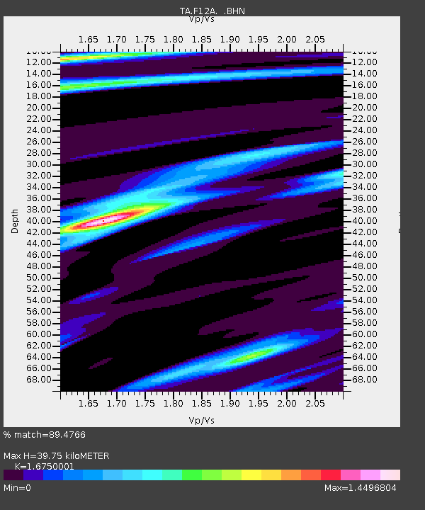
| Estimated Moho Depth: |
39.75 km |
| Estimated Crust Vp/Vs: |
1.68 |
| Assumed Crust Vp: |
6.577 km/s |
| Estimated Crust Vs: |
3.927 km/s |
| Estimated Crust Poisson's Ratio: |
0.22 |
|
| Radial Match: |
89.4766 % |
| Radial Bump: |
400 |
| Transverse Match: |
75.16604 % |
| Transverse Bump: |
400 |
| SOD ConfigId: |
2658 |
| Insert Time: |
2010-03-06 20:39:05.556 +0000 |
| GWidth: |
2.5 |
| Max Bumps: |
400 |
| Tol: |
0.001 |
|

Signal To Noise
| Channel | StoN | STA | LTA |
| TA:F12A: :BHN:20090312T23:31:49.64901Z | 11.232712 | 1.504107E-6 | 1.3390418E-7 |
| TA:F12A: :BHE:20090312T23:31:49.64901Z | 3.220348 | 4.4508445E-7 | 1.3821005E-7 |
| TA:F12A: :BHZ:20090312T23:31:49.64901Z | 5.5203695 | 5.0319005E-7 | 9.115151E-8 |
| Arrivals |
| Ps | 4.4 SECOND |
| PpPs | 15 SECOND |
| PsPs/PpSs | 19 SECOND |


