You are here: Home > Network List > TA - USArray Transportable Network (new EarthScope stations) Stations List
> Station D25K Kavik River, AK, USA > Earthquake Result Viewer
D25K Kavik River, AK, USA - Earthquake Result Viewer
| Earthquake location: |
Philippine Islands Region |
| Earthquake latitude/longitude: |
10.4/126.1 |
| Earthquake time(UTC): |
2019/03/08 (067) 15:06:16 GMT |
| Earthquake Depth: |
54 km |
| Earthquake Magnitude: |
6.0 Mww |
| Earthquake Catalog/Contributor: |
NEIC PDE/us |
|
| Network: |
TA USArray Transportable Network (new EarthScope stations) |
| Station: |
D25K Kavik River, AK, USA |
| Lat/Lon: |
69.32 N/146.38 W |
| Elevation: |
770 m |
|
| Distance: |
79.5 deg |
| Az: |
21.157 deg |
| Baz: |
271.412 deg |
| Ray Param: |
0.048824437 |
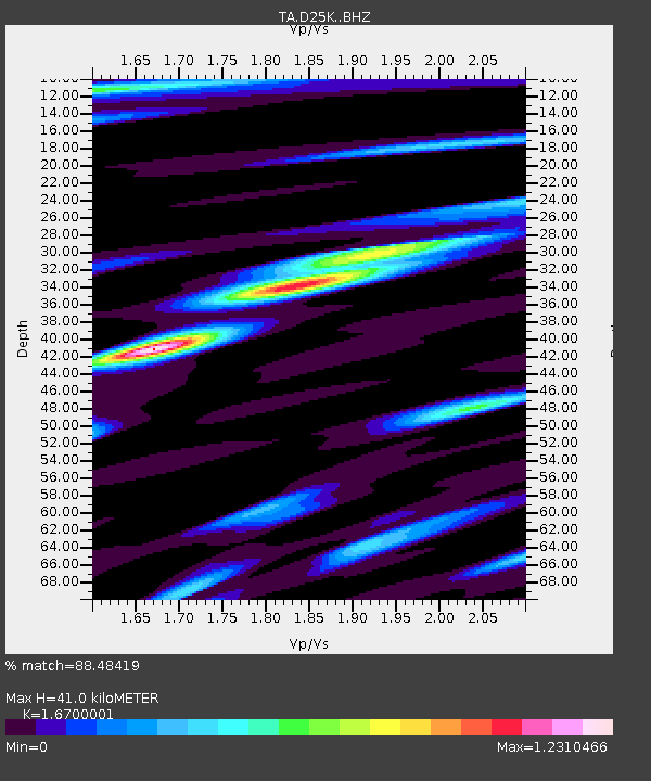
| Estimated Moho Depth: |
41.0 km |
| Estimated Crust Vp/Vs: |
1.67 |
| Assumed Crust Vp: |
6.378 km/s |
| Estimated Crust Vs: |
3.819 km/s |
| Estimated Crust Poisson's Ratio: |
0.22 |
|
| Radial Match: |
88.48419 % |
| Radial Bump: |
398 |
| Transverse Match: |
79.34982 % |
| Transverse Bump: |
400 |
| SOD ConfigId: |
13570011 |
| Insert Time: |
2019-05-02 16:55:23.596 +0000 |
| GWidth: |
2.5 |
| Max Bumps: |
400 |
| Tol: |
0.001 |
|
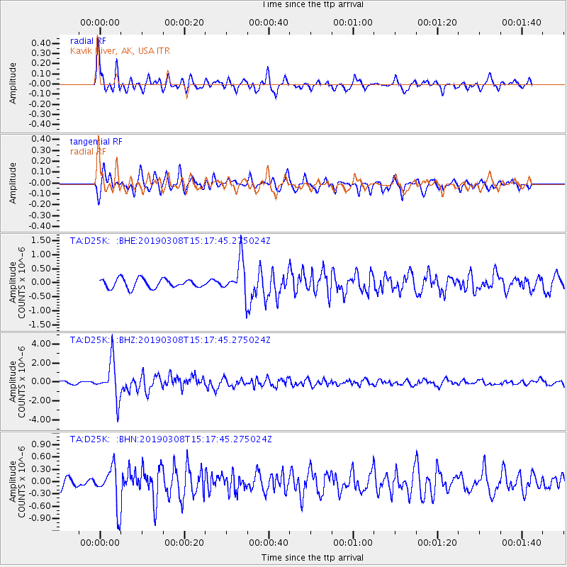
Signal To Noise
| Channel | StoN | STA | LTA |
| TA:D25K: :BHZ:20190308T15:17:45.275024Z | 15.523169 | 2.0198695E-6 | 1.3011967E-7 |
| TA:D25K: :BHN:20190308T15:17:45.275024Z | 3.8205588 | 4.9131165E-7 | 1.2859681E-7 |
| TA:D25K: :BHE:20190308T15:17:45.275024Z | 4.27918 | 6.9070984E-7 | 1.6141172E-7 |
| Arrivals |
| Ps | 4.4 SECOND |
| PpPs | 17 SECOND |
| PsPs/PpSs | 21 SECOND |


