You are here: Home > Network List > TA - USArray Transportable Network (new EarthScope stations) Stations List
> Station D23K Nanushuk River, AK USA > Earthquake Result Viewer
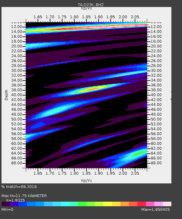
D23K Nanushuk River, AK USA - Earthquake Result Viewer
| Earthquake location: |
Philippine Islands Region |
| Earthquake latitude/longitude: |
10.4/126.1 |
| Earthquake time(UTC): |
2019/03/08 (067) 15:06:16 GMT |
| Earthquake Depth: |
54 km |
| Earthquake Magnitude: |
6.0 Mww |
| Earthquake Catalog/Contributor: |
NEIC PDE/us |
|
| Network: |
TA USArray Transportable Network (new EarthScope stations) |
| Station: |
D23K Nanushuk River, AK USA |
| Lat/Lon: |
68.97 N/150.68 W |
| Elevation: |
406 m |
|
| Distance: |
77.9 deg |
| Az: |
21.507 deg |
| Baz: |
267.46 deg |
| Ray Param: |
0.049874756 |
| Estimated Moho Depth: |
11.75 km |
| Estimated Crust Vp/Vs: |
1.93 |
| Assumed Crust Vp: |
6.221 km/s |
| Estimated Crust Vs: |
3.219 km/s |
| Estimated Crust Poisson's Ratio: |
0.32 |
|
| Radial Match: |
86.3016 % |
| Radial Bump: |
361 |
| Transverse Match: |
71.185936 % |
| Transverse Bump: |
400 |
| SOD ConfigId: |
13570011 |
| Insert Time: |
2019-05-02 16:55:23.250 +0000 |
| GWidth: |
2.5 |
| Max Bumps: |
400 |
| Tol: |
0.001 |
|

Signal To Noise
| Channel | StoN | STA | LTA |
| TA:D23K: :BHZ:20190308T15:17:36.825012Z | 10.382571 | 2.647583E-6 | 2.5500262E-7 |
| TA:D23K: :BHN:20190308T15:17:36.825012Z | 1.1719344 | 2.5088758E-7 | 2.1407989E-7 |
| TA:D23K: :BHE:20190308T15:17:36.825012Z | 4.793843 | 6.1907775E-7 | 1.2914019E-7 |
| Arrivals |
| Ps | 1.8 SECOND |
| PpPs | 5.4 SECOND |
| PsPs/PpSs | 7.2 SECOND |


