You are here: Home > Network List > TA - USArray Transportable Network (new EarthScope stations) Stations List
> Station F12A Elk City, ID, USA > Earthquake Result Viewer
F12A Elk City, ID, USA - Earthquake Result Viewer
| Earthquake location: |
Loyalty Islands |
| Earthquake latitude/longitude: |
-20.1/168.9 |
| Earthquake time(UTC): |
2008/04/09 (100) 12:46:12 GMT |
| Earthquake Depth: |
33 km |
| Earthquake Magnitude: |
6.3 MB, 7.3 MS, 7.3 MW, 7.3 MW |
| Earthquake Catalog/Contributor: |
WHDF/NEIC |
|
| Network: |
TA USArray Transportable Network (new EarthScope stations) |
| Station: |
F12A Elk City, ID, USA |
| Lat/Lon: |
45.76 N/115.25 W |
| Elevation: |
1442 m |
|
| Distance: |
94.7 deg |
| Az: |
42.939 deg |
| Baz: |
246.154 deg |
| Ray Param: |
0.040951405 |
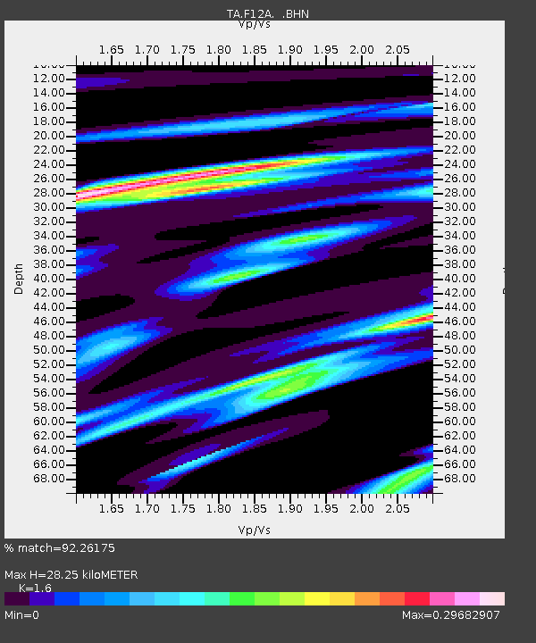
| Estimated Moho Depth: |
28.25 km |
| Estimated Crust Vp/Vs: |
1.60 |
| Assumed Crust Vp: |
6.577 km/s |
| Estimated Crust Vs: |
4.111 km/s |
| Estimated Crust Poisson's Ratio: |
0.18 |
|
| Radial Match: |
92.26175 % |
| Radial Bump: |
219 |
| Transverse Match: |
83.07997 % |
| Transverse Bump: |
298 |
| SOD ConfigId: |
2504 |
| Insert Time: |
2010-03-06 20:39:21.763 +0000 |
| GWidth: |
2.5 |
| Max Bumps: |
400 |
| Tol: |
0.001 |
|

Signal To Noise
| Channel | StoN | STA | LTA |
| TA:F12A: :BHN:20080409T12:58:59.399016Z | 17.530933 | 2.3617897E-6 | 1.3472128E-7 |
| TA:F12A: :BHE:20080409T12:58:59.399016Z | 2.235067 | 4.9001005E-7 | 2.1923731E-7 |
| TA:F12A: :BHZ:20080409T12:58:59.399016Z | 3.8194358 | 7.38776E-7 | 1.9342542E-7 |
| Arrivals |
| Ps | 2.6 SECOND |
| PpPs | 11 SECOND |
| PsPs/PpSs | 14 SECOND |


