You are here: Home > Network List > TA - USArray Transportable Network (new EarthScope stations) Stations List
> Station F21K Alatna River, AK, USA > Earthquake Result Viewer
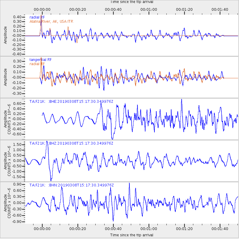
F21K Alatna River, AK, USA - Earthquake Result Viewer
*The percent match for this event was below the threshold and hence no stack was calculated.
| Earthquake location: |
Philippine Islands Region |
| Earthquake latitude/longitude: |
10.4/126.1 |
| Earthquake time(UTC): |
2019/03/08 (067) 15:06:16 GMT |
| Earthquake Depth: |
54 km |
| Earthquake Magnitude: |
6.0 Mww |
| Earthquake Catalog/Contributor: |
NEIC PDE/us |
|
| Network: |
TA USArray Transportable Network (new EarthScope stations) |
| Station: |
F21K Alatna River, AK, USA |
| Lat/Lon: |
67.22 N/153.48 W |
| Elevation: |
597 m |
|
| Distance: |
76.8 deg |
| Az: |
23.229 deg |
| Baz: |
265.239 deg |
| Ray Param: |
$rayparam |
*The percent match for this event was below the threshold and hence was not used in the summary stack. |
|
| Radial Match: |
74.980545 % |
| Radial Bump: |
400 |
| Transverse Match: |
64.25103 % |
| Transverse Bump: |
400 |
| SOD ConfigId: |
13570011 |
| Insert Time: |
2019-05-02 16:55:40.640 +0000 |
| GWidth: |
2.5 |
| Max Bumps: |
400 |
| Tol: |
0.001 |
|
Signal To Noise
| Channel | StoN | STA | LTA |
| TA:F21K: :BHZ:20190308T15:17:30.349976Z | 7.314951 | 9.147619E-7 | 1.2505373E-7 |
| TA:F21K: :BHN:20190308T15:17:30.349976Z | 1.0248903 | 2.0250151E-7 | 1.9758359E-7 |
| TA:F21K: :BHE:20190308T15:17:30.349976Z | 2.3000205 | 3.1123156E-7 | 1.3531687E-7 |
| Arrivals |
| Ps | |
| PpPs | |
| PsPs/PpSs | |


