You are here: Home > Network List > TA - USArray Transportable Network (new EarthScope stations) Stations List
> Station G23K Bananza Creek, AK, USA > Earthquake Result Viewer
G23K Bananza Creek, AK, USA - Earthquake Result Viewer
| Earthquake location: |
Philippine Islands Region |
| Earthquake latitude/longitude: |
10.4/126.1 |
| Earthquake time(UTC): |
2019/03/08 (067) 15:06:16 GMT |
| Earthquake Depth: |
54 km |
| Earthquake Magnitude: |
6.0 Mww |
| Earthquake Catalog/Contributor: |
NEIC PDE/us |
|
| Network: |
TA USArray Transportable Network (new EarthScope stations) |
| Station: |
G23K Bananza Creek, AK, USA |
| Lat/Lon: |
66.71 N/150.02 W |
| Elevation: |
746 m |
|
| Distance: |
78.1 deg |
| Az: |
23.83 deg |
| Baz: |
268.55 deg |
| Ray Param: |
0.049759086 |
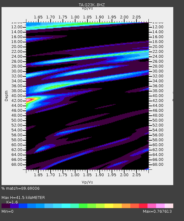
| Estimated Moho Depth: |
41.5 km |
| Estimated Crust Vp/Vs: |
1.60 |
| Assumed Crust Vp: |
6.577 km/s |
| Estimated Crust Vs: |
4.11 km/s |
| Estimated Crust Poisson's Ratio: |
0.18 |
|
| Radial Match: |
89.69006 % |
| Radial Bump: |
339 |
| Transverse Match: |
71.40477 % |
| Transverse Bump: |
342 |
| SOD ConfigId: |
13570011 |
| Insert Time: |
2019-05-02 16:55:50.567 +0000 |
| GWidth: |
2.5 |
| Max Bumps: |
400 |
| Tol: |
0.001 |
|
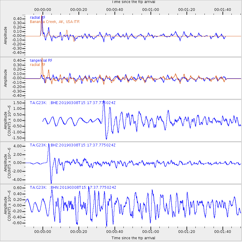
Signal To Noise
| Channel | StoN | STA | LTA |
| TA:G23K: :BHZ:20190308T15:17:37.775024Z | 10.842991 | 2.07775E-6 | 1.9162148E-7 |
| TA:G23K: :BHN:20190308T15:17:37.775024Z | 1.360895 | 2.2232125E-7 | 1.6336399E-7 |
| TA:G23K: :BHE:20190308T15:17:37.775024Z | 3.187952 | 6.963066E-7 | 2.1841814E-7 |
| Arrivals |
| Ps | 3.9 SECOND |
| PpPs | 16 SECOND |
| PsPs/PpSs | 20 SECOND |


