You are here: Home > Network List > TA - USArray Transportable Network (new EarthScope stations) Stations List
> Station H27K Steamboat Mountain, AK, USA > Earthquake Result Viewer
H27K Steamboat Mountain, AK, USA - Earthquake Result Viewer
| Earthquake location: |
Philippine Islands Region |
| Earthquake latitude/longitude: |
10.4/126.1 |
| Earthquake time(UTC): |
2019/03/08 (067) 15:06:16 GMT |
| Earthquake Depth: |
54 km |
| Earthquake Magnitude: |
6.0 Mww |
| Earthquake Catalog/Contributor: |
NEIC PDE/us |
|
| Network: |
TA USArray Transportable Network (new EarthScope stations) |
| Station: |
H27K Steamboat Mountain, AK, USA |
| Lat/Lon: |
66.23 N/141.53 W |
| Elevation: |
786 m |
|
| Distance: |
81.5 deg |
| Az: |
24.169 deg |
| Baz: |
276.395 deg |
| Ray Param: |
0.047413915 |
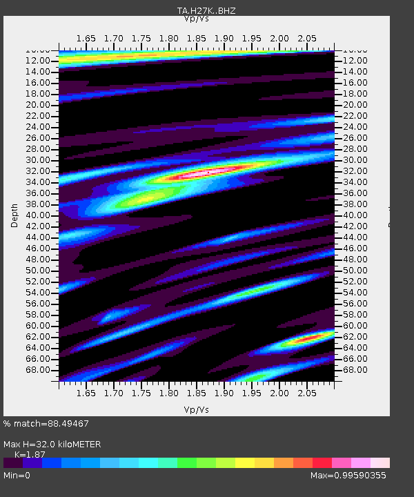
| Estimated Moho Depth: |
32.0 km |
| Estimated Crust Vp/Vs: |
1.87 |
| Assumed Crust Vp: |
6.577 km/s |
| Estimated Crust Vs: |
3.517 km/s |
| Estimated Crust Poisson's Ratio: |
0.30 |
|
| Radial Match: |
88.49467 % |
| Radial Bump: |
400 |
| Transverse Match: |
75.55854 % |
| Transverse Bump: |
327 |
| SOD ConfigId: |
13570011 |
| Insert Time: |
2019-05-02 16:56:03.027 +0000 |
| GWidth: |
2.5 |
| Max Bumps: |
400 |
| Tol: |
0.001 |
|

Signal To Noise
| Channel | StoN | STA | LTA |
| TA:H27K: :BHZ:20190308T15:17:56.250Z | 8.903436 | 1.5041809E-6 | 1.6894387E-7 |
| TA:H27K: :BHN:20190308T15:17:56.250Z | 0.47201988 | 6.453787E-8 | 1.3672702E-7 |
| TA:H27K: :BHE:20190308T15:17:56.250Z | 4.273393 | 6.170521E-7 | 1.4439395E-7 |
| Arrivals |
| Ps | 4.3 SECOND |
| PpPs | 14 SECOND |
| PsPs/PpSs | 18 SECOND |


