You are here: Home > Network List > TA - USArray Transportable Network (new EarthScope stations) Stations List
> Station I29M Ogilvie Camp, Yukon, CA > Earthquake Result Viewer
I29M Ogilvie Camp, Yukon, CA - Earthquake Result Viewer
| Earthquake location: |
Philippine Islands Region |
| Earthquake latitude/longitude: |
10.4/126.1 |
| Earthquake time(UTC): |
2019/03/08 (067) 15:06:16 GMT |
| Earthquake Depth: |
54 km |
| Earthquake Magnitude: |
6.0 Mww |
| Earthquake Catalog/Contributor: |
NEIC PDE/us |
|
| Network: |
TA USArray Transportable Network (new EarthScope stations) |
| Station: |
I29M Ogilvie Camp, Yukon, CA |
| Lat/Lon: |
65.36 N/138.31 W |
| Elevation: |
602 m |
|
| Distance: |
83.0 deg |
| Az: |
24.858 deg |
| Baz: |
279.422 deg |
| Ray Param: |
0.04641655 |
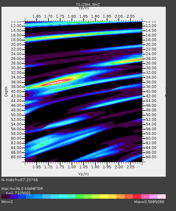
| Estimated Moho Depth: |
36.0 km |
| Estimated Crust Vp/Vs: |
1.73 |
| Assumed Crust Vp: |
6.566 km/s |
| Estimated Crust Vs: |
3.79 km/s |
| Estimated Crust Poisson's Ratio: |
0.25 |
|
| Radial Match: |
87.23746 % |
| Radial Bump: |
342 |
| Transverse Match: |
79.2852 % |
| Transverse Bump: |
400 |
| SOD ConfigId: |
13570011 |
| Insert Time: |
2019-05-02 16:56:12.218 +0000 |
| GWidth: |
2.5 |
| Max Bumps: |
400 |
| Tol: |
0.001 |
|

Signal To Noise
| Channel | StoN | STA | LTA |
| TA:I29M: :BHZ:20190308T15:18:03.724976Z | 20.582117 | 2.3834186E-6 | 1.1580046E-7 |
| TA:I29M: :BHN:20190308T15:18:03.724976Z | 2.058705 | 3.186547E-7 | 1.5478405E-7 |
| TA:I29M: :BHE:20190308T15:18:03.724976Z | 5.18052 | 7.979775E-7 | 1.5403425E-7 |
| Arrivals |
| Ps | 4.1 SECOND |
| PpPs | 15 SECOND |
| PsPs/PpSs | 19 SECOND |


