You are here: Home > Network List > TA - USArray Transportable Network (new EarthScope stations) Stations List
> Station L15K Ungalak Mountain, AK, USA > Earthquake Result Viewer
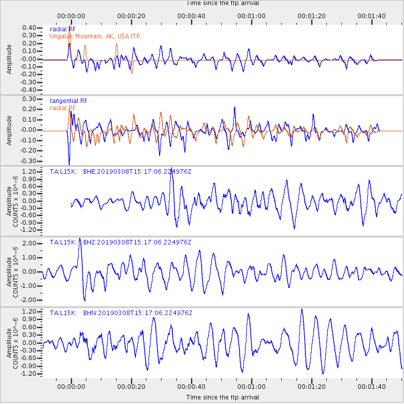
L15K Ungalak Mountain, AK, USA - Earthquake Result Viewer
*The percent match for this event was below the threshold and hence no stack was calculated.
| Earthquake location: |
Philippine Islands Region |
| Earthquake latitude/longitude: |
10.4/126.1 |
| Earthquake time(UTC): |
2019/03/08 (067) 15:06:16 GMT |
| Earthquake Depth: |
54 km |
| Earthquake Magnitude: |
6.0 Mww |
| Earthquake Catalog/Contributor: |
NEIC PDE/us |
|
| Network: |
TA USArray Transportable Network (new EarthScope stations) |
| Station: |
L15K Ungalak Mountain, AK, USA |
| Lat/Lon: |
61.68 N/161.49 W |
| Elevation: |
219 m |
|
| Distance: |
72.6 deg |
| Az: |
28.455 deg |
| Baz: |
259.398 deg |
| Ray Param: |
$rayparam |
*The percent match for this event was below the threshold and hence was not used in the summary stack. |
|
| Radial Match: |
57.968666 % |
| Radial Bump: |
400 |
| Transverse Match: |
67.00516 % |
| Transverse Bump: |
400 |
| SOD ConfigId: |
13570011 |
| Insert Time: |
2019-05-02 16:56:39.862 +0000 |
| GWidth: |
2.5 |
| Max Bumps: |
400 |
| Tol: |
0.001 |
|
Signal To Noise
| Channel | StoN | STA | LTA |
| TA:L15K: :BHZ:20190308T15:17:06.224976Z | 5.1552825 | 1.1768773E-6 | 2.2828569E-7 |
| TA:L15K: :BHN:20190308T15:17:06.224976Z | 0.5093041 | 1.9392782E-7 | 3.8077016E-7 |
| TA:L15K: :BHE:20190308T15:17:06.224976Z | 3.9308925 | 6.5020896E-7 | 1.6541001E-7 |
| Arrivals |
| Ps | |
| PpPs | |
| PsPs/PpSs | |


