You are here: Home > Network List > IU - Global Seismograph Network (GSN - IRIS/USGS) Stations List
> Station JOHN Johnston Island, USA > Earthquake Result Viewer
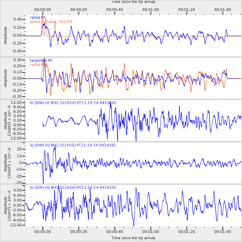
JOHN Johnston Island, USA - Earthquake Result Viewer
*The percent match for this event was below the threshold and hence no stack was calculated.
| Earthquake location: |
Fiji Islands Region |
| Earthquake latitude/longitude: |
-19.8/-178.3 |
| Earthquake time(UTC): |
2016/09/24 (268) 21:28:42 GMT |
| Earthquake Depth: |
594 km |
| Earthquake Magnitude: |
6.8 MO |
| Earthquake Catalog/Contributor: |
NEIC PDE/NEIC ALERT |
|
| Network: |
IU Global Seismograph Network (GSN - IRIS/USGS) |
| Station: |
JOHN Johnston Island, USA |
| Lat/Lon: |
16.73 N/169.53 W |
| Elevation: |
2.0 m |
|
| Distance: |
37.3 deg |
| Az: |
13.889 deg |
| Baz: |
193.641 deg |
| Ray Param: |
$rayparam |
*The percent match for this event was below the threshold and hence was not used in the summary stack. |
|
| Radial Match: |
68.9904 % |
| Radial Bump: |
400 |
| Transverse Match: |
61.81865 % |
| Transverse Bump: |
400 |
| SOD ConfigId: |
1634031 |
| Insert Time: |
2016-10-08 21:30:37.765 +0000 |
| GWidth: |
2.5 |
| Max Bumps: |
400 |
| Tol: |
0.001 |
|
Signal To Noise
| Channel | StoN | STA | LTA |
| IU:JOHN:00:BHZ:20160924T21:34:34.843994Z | 9.302333 | 1.2504608E-5 | 1.3442443E-6 |
| IU:JOHN:00:BH1:20160924T21:34:34.843994Z | 1.99699 | 3.6326778E-6 | 1.8190766E-6 |
| IU:JOHN:00:BH2:20160924T21:34:34.843994Z | 2.1888442 | 4.1260137E-6 | 1.8850195E-6 |
| Arrivals |
| Ps | |
| PpPs | |
| PsPs/PpSs | |


