You are here: Home > Network List > AU - Australian Seismological Centre Stations List
> Station WB2 Warramunga Array, Australia > Earthquake Result Viewer
WB2 Warramunga Array, Australia - Earthquake Result Viewer
| Earthquake location: |
Fiji Islands Region |
| Earthquake latitude/longitude: |
-17.8/-178.7 |
| Earthquake time(UTC): |
2019/03/10 (069) 08:12:25 GMT |
| Earthquake Depth: |
567 km |
| Earthquake Magnitude: |
6.2 Mww |
| Earthquake Catalog/Contributor: |
NEIC PDE/us |
|
| Network: |
AU Australian Seismological Centre |
| Station: |
WB2 Warramunga Array, Australia |
| Lat/Lon: |
19.94 S/134.35 E |
| Elevation: |
388 m |
|
| Distance: |
44.4 deg |
| Az: |
259.487 deg |
| Baz: |
95.413 deg |
| Ray Param: |
0.069146216 |
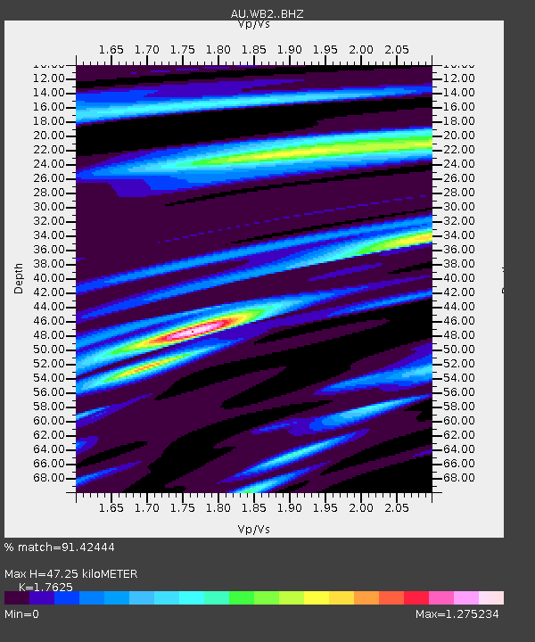
| Estimated Moho Depth: |
47.25 km |
| Estimated Crust Vp/Vs: |
1.76 |
| Assumed Crust Vp: |
6.642 km/s |
| Estimated Crust Vs: |
3.769 km/s |
| Estimated Crust Poisson's Ratio: |
0.26 |
|
| Radial Match: |
91.42444 % |
| Radial Bump: |
400 |
| Transverse Match: |
75.399994 % |
| Transverse Bump: |
400 |
| SOD ConfigId: |
13570011 |
| Insert Time: |
2019-05-02 17:03:49.526 +0000 |
| GWidth: |
2.5 |
| Max Bumps: |
400 |
| Tol: |
0.001 |
|

Signal To Noise
| Channel | StoN | STA | LTA |
| AU:WB2: :BHZ:20190310T08:19:16.400013Z | 27.541374 | 5.674139E-6 | 2.0602236E-7 |
| AU:WB2: :BHN:20190310T08:19:16.400013Z | 2.2067108 | 8.305253E-7 | 3.7636346E-7 |
| AU:WB2: :BHE:20190310T08:19:16.400013Z | 20.805834 | 2.8529726E-6 | 1.3712368E-7 |
| Arrivals |
| Ps | 5.8 SECOND |
| PpPs | 18 SECOND |
| PsPs/PpSs | 24 SECOND |


