You are here: Home > Network List > IW - Intermountain West Stations List
> Station MOOW Moose Ponds, Wyoming, USA > Earthquake Result Viewer
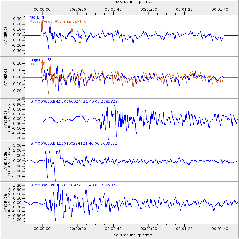
MOOW Moose Ponds, Wyoming, USA - Earthquake Result Viewer
*The percent match for this event was below the threshold and hence no stack was calculated.
| Earthquake location: |
Fiji Islands Region |
| Earthquake latitude/longitude: |
-19.8/-178.3 |
| Earthquake time(UTC): |
2016/09/24 (268) 21:28:42 GMT |
| Earthquake Depth: |
594 km |
| Earthquake Magnitude: |
6.8 MO |
| Earthquake Catalog/Contributor: |
NEIC PDE/NEIC ALERT |
|
| Network: |
IW Intermountain West |
| Station: |
MOOW Moose Ponds, Wyoming, USA |
| Lat/Lon: |
43.75 N/110.74 W |
| Elevation: |
2128 m |
|
| Distance: |
88.4 deg |
| Az: |
42.061 deg |
| Baz: |
240.485 deg |
| Ray Param: |
$rayparam |
*The percent match for this event was below the threshold and hence was not used in the summary stack. |
|
| Radial Match: |
78.98836 % |
| Radial Bump: |
400 |
| Transverse Match: |
84.981186 % |
| Transverse Bump: |
400 |
| SOD ConfigId: |
1634031 |
| Insert Time: |
2016-10-08 21:31:13.322 +0000 |
| GWidth: |
2.5 |
| Max Bumps: |
400 |
| Tol: |
0.001 |
|
Signal To Noise
| Channel | StoN | STA | LTA |
| IW:MOOW:00:BHZ:20160924T21:40:00.268982Z | 12.770999 | 1.289876E-6 | 1.01000396E-7 |
| IW:MOOW:00:BH1:20160924T21:40:00.268982Z | 3.3158891 | 2.3273502E-7 | 7.018782E-8 |
| IW:MOOW:00:BH2:20160924T21:40:00.268982Z | 1.905689 | 2.3647222E-7 | 1.2408752E-7 |
| Arrivals |
| Ps | |
| PpPs | |
| PsPs/PpSs | |


