You are here: Home > Network List > TA - USArray Transportable Network (new EarthScope stations) Stations List
> Station C16K Lisburne Hills, AK, USA > Earthquake Result Viewer
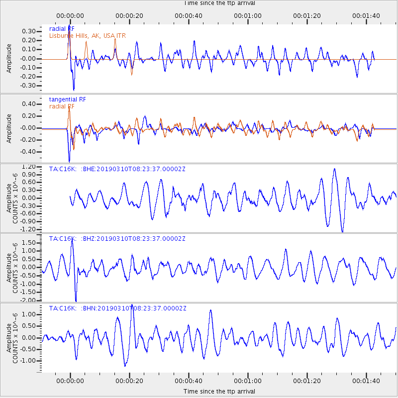
C16K Lisburne Hills, AK, USA - Earthquake Result Viewer
*The percent match for this event was below the threshold and hence no stack was calculated.
| Earthquake location: |
Fiji Islands Region |
| Earthquake latitude/longitude: |
-17.8/-178.7 |
| Earthquake time(UTC): |
2019/03/10 (069) 08:12:25 GMT |
| Earthquake Depth: |
567 km |
| Earthquake Magnitude: |
6.2 Mww |
| Earthquake Catalog/Contributor: |
NEIC PDE/us |
|
| Network: |
TA USArray Transportable Network (new EarthScope stations) |
| Station: |
C16K Lisburne Hills, AK, USA |
| Lat/Lon: |
68.27 N/165.34 W |
| Elevation: |
102 m |
|
| Distance: |
86.4 deg |
| Az: |
4.93 deg |
| Baz: |
192.701 deg |
| Ray Param: |
$rayparam |
*The percent match for this event was below the threshold and hence was not used in the summary stack. |
|
| Radial Match: |
50.78324 % |
| Radial Bump: |
400 |
| Transverse Match: |
44.635033 % |
| Transverse Bump: |
384 |
| SOD ConfigId: |
13570011 |
| Insert Time: |
2019-05-02 17:09:59.303 +0000 |
| GWidth: |
2.5 |
| Max Bumps: |
400 |
| Tol: |
0.001 |
|
Signal To Noise
| Channel | StoN | STA | LTA |
| TA:C16K: :BHZ:20190310T08:23:37.00002Z | 2.331077 | 8.685255E-7 | 3.7258548E-7 |
| TA:C16K: :BHN:20190310T08:23:37.00002Z | 0.9186526 | 3.6190136E-7 | 3.9394803E-7 |
| TA:C16K: :BHE:20190310T08:23:37.00002Z | 2.0013964 | 4.61245E-7 | 2.3046161E-7 |
| Arrivals |
| Ps | |
| PpPs | |
| PsPs/PpSs | |


