You are here: Home > Network List > UW - Pacific Northwest Regional Seismic Network Stations List
> Station UMAT Pilot Rock, OR, USA > Earthquake Result Viewer
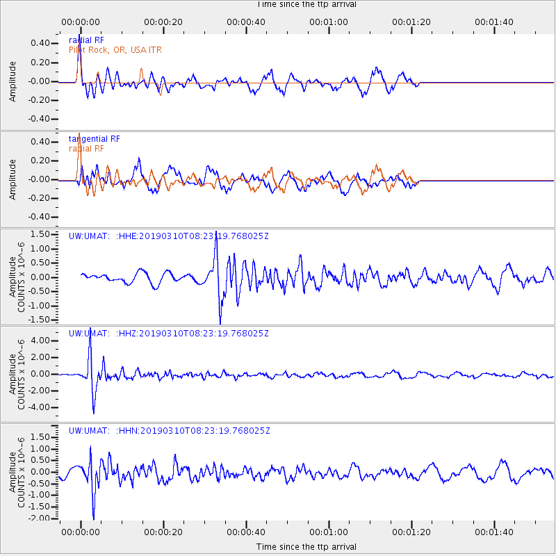
UMAT Pilot Rock, OR, USA - Earthquake Result Viewer
*The percent match for this event was below the threshold and hence no stack was calculated.
| Earthquake location: |
Fiji Islands Region |
| Earthquake latitude/longitude: |
-17.8/-178.7 |
| Earthquake time(UTC): |
2019/03/10 (069) 08:12:25 GMT |
| Earthquake Depth: |
567 km |
| Earthquake Magnitude: |
6.2 Mww |
| Earthquake Catalog/Contributor: |
NEIC PDE/us |
|
| Network: |
UW Pacific Northwest Regional Seismic Network |
| Station: |
UMAT Pilot Rock, OR, USA |
| Lat/Lon: |
45.29 N/118.96 W |
| Elevation: |
1318 m |
|
| Distance: |
82.9 deg |
| Az: |
37.894 deg |
| Baz: |
235.977 deg |
| Ray Param: |
$rayparam |
*The percent match for this event was below the threshold and hence was not used in the summary stack. |
|
| Radial Match: |
71.37683 % |
| Radial Bump: |
378 |
| Transverse Match: |
75.067986 % |
| Transverse Bump: |
400 |
| SOD ConfigId: |
13570011 |
| Insert Time: |
2019-05-02 17:13:29.483 +0000 |
| GWidth: |
2.5 |
| Max Bumps: |
400 |
| Tol: |
0.001 |
|
Signal To Noise
| Channel | StoN | STA | LTA |
| UW:UMAT: :HHZ:20190310T08:23:19.768025Z | 14.282656 | 2.0451735E-6 | 1.4319279E-7 |
| UW:UMAT: :HHN:20190310T08:23:19.768025Z | 3.222252 | 6.601145E-7 | 2.0486124E-7 |
| UW:UMAT: :HHE:20190310T08:23:19.768025Z | 4.3602653 | 7.2862485E-7 | 1.6710563E-7 |
| Arrivals |
| Ps | |
| PpPs | |
| PsPs/PpSs | |


