You are here: Home > Network List > CI - Caltech Regional Seismic Network Stations List
> Station MPM Manuel Prospect Mine, California, USA > Earthquake Result Viewer
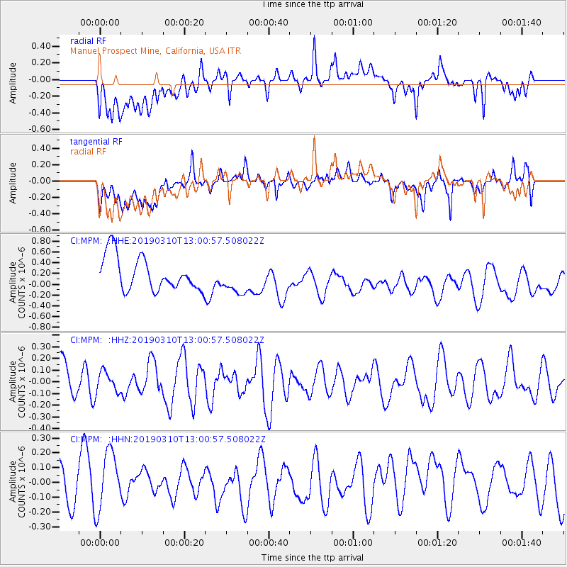
MPM Manuel Prospect Mine, California, USA - Earthquake Result Viewer
*The percent match for this event was below the threshold and hence no stack was calculated.
| Earthquake location: |
D'Entrecasteaux Islands Region |
| Earthquake latitude/longitude: |
-10.1/152.1 |
| Earthquake time(UTC): |
2019/03/10 (069) 12:48:00 GMT |
| Earthquake Depth: |
10 km |
| Earthquake Magnitude: |
6.1 Mww |
| Earthquake Catalog/Contributor: |
NEIC PDE/us |
|
| Network: |
CI Caltech Regional Seismic Network |
| Station: |
MPM Manuel Prospect Mine, California, USA |
| Lat/Lon: |
36.06 N/117.49 W |
| Elevation: |
185 m |
|
| Distance: |
96.2 deg |
| Az: |
54.599 deg |
| Baz: |
262.072 deg |
| Ray Param: |
$rayparam |
*The percent match for this event was below the threshold and hence was not used in the summary stack. |
|
| Radial Match: |
48.79118 % |
| Radial Bump: |
400 |
| Transverse Match: |
55.040943 % |
| Transverse Bump: |
400 |
| SOD ConfigId: |
13570011 |
| Insert Time: |
2019-05-02 17:16:04.882 +0000 |
| GWidth: |
2.5 |
| Max Bumps: |
400 |
| Tol: |
0.001 |
|
Signal To Noise
| Channel | StoN | STA | LTA |
| CI:MPM: :HHZ:20190310T13:00:57.508022Z | 0.47282976 | 8.5080075E-8 | 1.7993808E-7 |
| CI:MPM: :HHN:20190310T13:00:57.508022Z | 1.5685097 | 2.2766461E-7 | 1.451471E-7 |
| CI:MPM: :HHE:20190310T13:00:57.508022Z | 0.9203266 | 2.890541E-7 | 3.1407774E-7 |
| Arrivals |
| Ps | |
| PpPs | |
| PsPs/PpSs | |


