You are here: Home > Network List > TA - USArray Transportable Network (new EarthScope stations) Stations List
> Station R11A Troy Canyon, Currant, NV, USA > Earthquake Result Viewer
R11A Troy Canyon, Currant, NV, USA - Earthquake Result Viewer
| Earthquake location: |
North Of Honduras |
| Earthquake latitude/longitude: |
16.7/-86.2 |
| Earthquake time(UTC): |
2009/05/28 (148) 08:24:45 GMT |
| Earthquake Depth: |
10 km |
| Earthquake Magnitude: |
6.7 MB, 7.2 MS, 7.3 MW, 7.3 MW |
| Earthquake Catalog/Contributor: |
WHDF/NEIC |
|
| Network: |
TA USArray Transportable Network (new EarthScope stations) |
| Station: |
R11A Troy Canyon, Currant, NV, USA |
| Lat/Lon: |
38.35 N/115.59 W |
| Elevation: |
1756 m |
|
| Distance: |
33.6 deg |
| Az: |
315.786 deg |
| Baz: |
121.802 deg |
| Ray Param: |
0.07815518 |
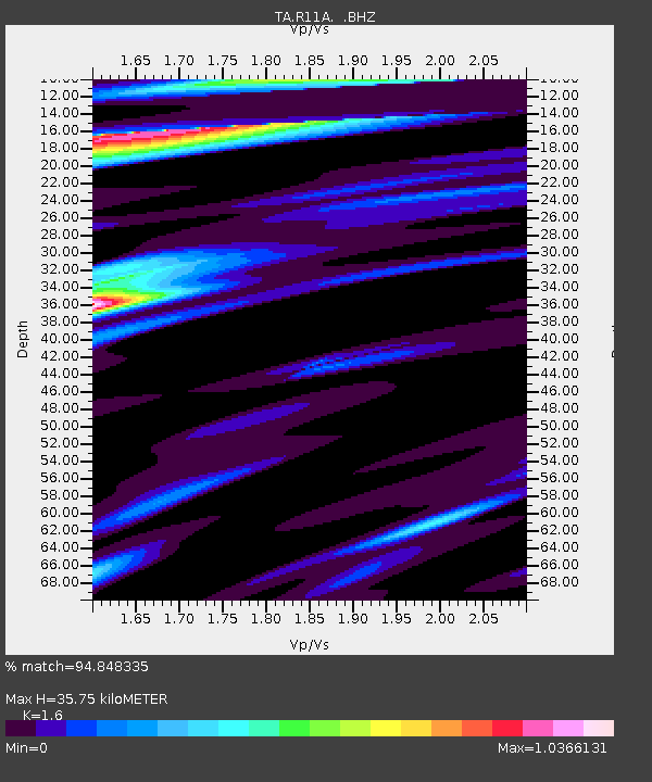
| Estimated Moho Depth: |
35.75 km |
| Estimated Crust Vp/Vs: |
1.60 |
| Assumed Crust Vp: |
6.276 km/s |
| Estimated Crust Vs: |
3.922 km/s |
| Estimated Crust Poisson's Ratio: |
0.18 |
|
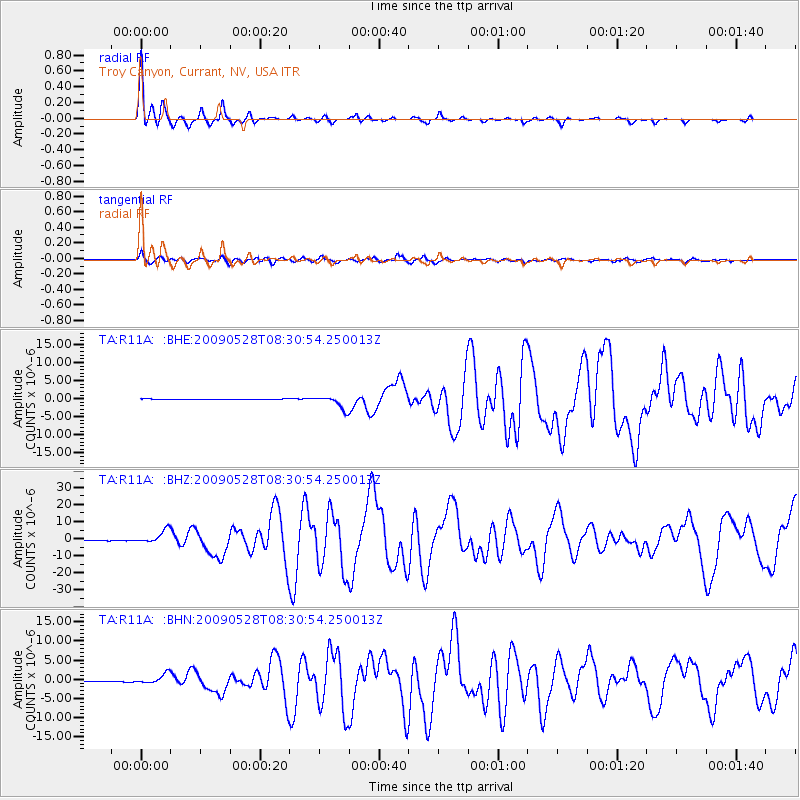
| Radial Match: |
94.848335 % |
| Radial Bump: |
373 |
| Transverse Match: |
85.31802 % |
| Transverse Bump: |
400 |
| SOD ConfigId: |
2648 |
| Insert Time: |
2010-03-06 20:42:42.871 +0000 |
| GWidth: |
2.5 |
| Max Bumps: |
400 |
| Tol: |
0.001 |
|
Signal To Noise
| Channel | StoN | STA | LTA |
| TA:R11A: :BHZ:20090528T08:30:54.250013Z | 36.38136 | 3.906959E-6 | 1.0738905E-7 |
| TA:R11A: :BHN:20090528T08:30:54.250013Z | 23.560474 | 1.2938061E-6 | 5.4914263E-8 |
| TA:R11A: :BHE:20090528T08:30:54.250013Z | 34.542805 | 1.863866E-6 | 5.3958157E-8 |
| Arrivals |
| Ps | 3.7 SECOND |
| PpPs | 14 SECOND |
| PsPs/PpSs | 17 SECOND |


