You are here: Home > Network List > MM - Myanmar National Seismic Network Stations List
> Station NGU Ngaung U, Myanmar > Earthquake Result Viewer
NGU Ngaung U, Myanmar - Earthquake Result Viewer
| Earthquake location: |
Off East Coast Of Honshu, Japan |
| Earthquake latitude/longitude: |
36.9/142.4 |
| Earthquake time(UTC): |
2019/03/10 (069) 17:10:52 GMT |
| Earthquake Depth: |
15 km |
| Earthquake Magnitude: |
5.8 Mww |
| Earthquake Catalog/Contributor: |
NEIC PDE/us |
|
| Network: |
MM Myanmar National Seismic Network |
| Station: |
NGU Ngaung U, Myanmar |
| Lat/Lon: |
21.21 N/94.92 E |
| Elevation: |
70 m |
|
| Distance: |
43.9 deg |
| Az: |
262.676 deg |
| Baz: |
58.496 deg |
| Ray Param: |
0.07225545 |
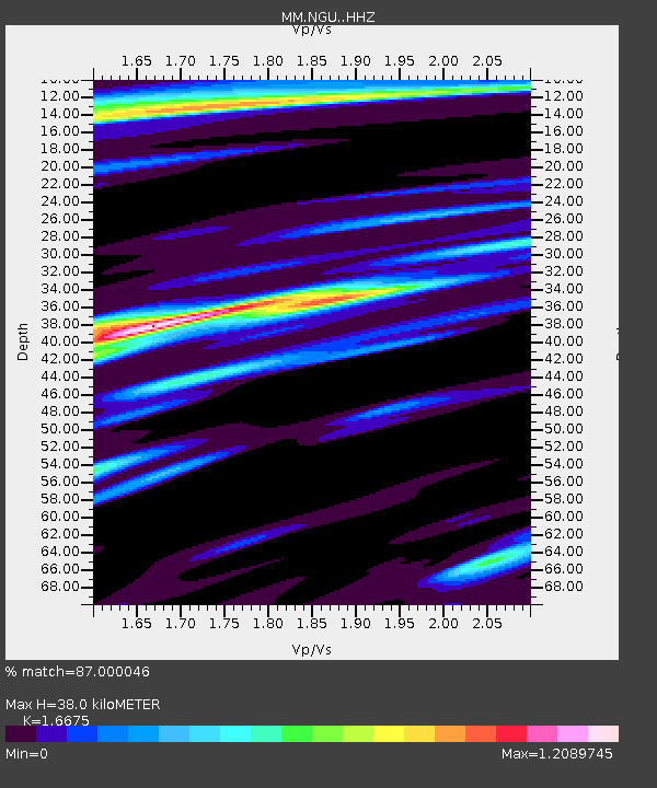
| Estimated Moho Depth: |
38.0 km |
| Estimated Crust Vp/Vs: |
1.67 |
| Assumed Crust Vp: |
6.036 km/s |
| Estimated Crust Vs: |
3.62 km/s |
| Estimated Crust Poisson's Ratio: |
0.22 |
|
| Radial Match: |
87.000046 % |
| Radial Bump: |
400 |
| Transverse Match: |
69.460335 % |
| Transverse Bump: |
400 |
| SOD ConfigId: |
13570011 |
| Insert Time: |
2019-05-02 17:23:59.986 +0000 |
| GWidth: |
2.5 |
| Max Bumps: |
400 |
| Tol: |
0.001 |
|

Signal To Noise
| Channel | StoN | STA | LTA |
| MM:NGU: :HHZ:20190310T17:18:27.510009Z | 20.290611 | 2.9468156E-6 | 1.452305E-7 |
| MM:NGU: :HHN:20190310T17:18:27.510009Z | 4.192525 | 5.6281374E-7 | 1.342422E-7 |
| MM:NGU: :HHE:20190310T17:18:27.510009Z | 7.1980386 | 8.6237486E-7 | 1.1980693E-7 |
| Arrivals |
| Ps | 4.5 SECOND |
| PpPs | 16 SECOND |
| PsPs/PpSs | 20 SECOND |


