DGR Domenigoni Valley Reservior, California, USA - Earthquake Result Viewer
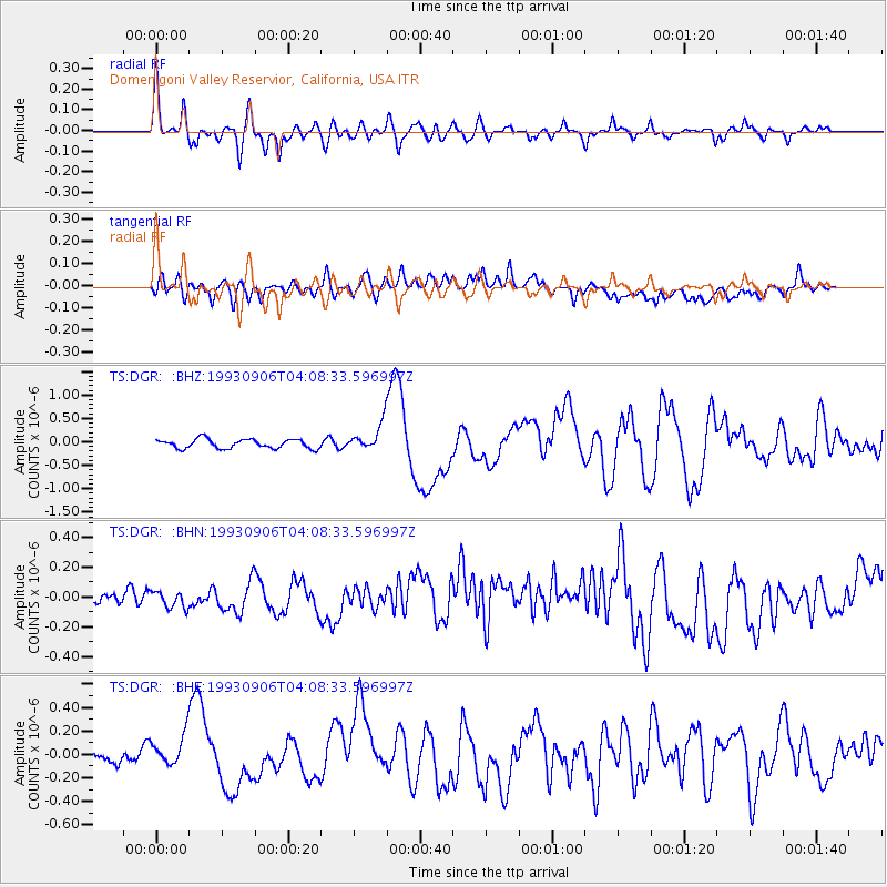
Earthquake location: New Ireland Region, P.N.G.
Earthquake latitude/longitude: -4.7/153.2
Earthquake time(UTC): 1993/09/06 (249) 03:56:02 GMT
Earthquake Depth: 73 km
Earthquake Magnitude: 6.0 MB, 6.6 MS, 6.7 UNKNOWN, 6.6 MW
Earthquake Catalog/Contributor: WHDF/NEIC
Network: TS TERRAscope (Southern California Seismic Network)
Station: DGR Domenigoni Valley Reservior, California, USA
Lat/Lon: 33.65 N/117.01 W
Elevation: 700 m
Distance: 92.4 deg
Az: 56.603 deg
Baz: 265.972 deg
Ray Param: 0.04143059
Estimated Moho Depth: 32.75 km
Estimated Crust Vp/Vs: 1.81
Assumed Crust Vp: 6.264 km/s
Estimated Crust Vs: 3.465 km/s
Estimated Crust Poisson's Ratio: 0.28
Radial Match: 82.48284 %
Radial Bump: 400
Transverse Match: 64.61372 %
Transverse Bump: 400
SOD ConfigId: 16938
Insert Time: 2010-02-26 14:07:18.361 +0000
GWidth: 2.5
Max Bumps: 400
Tol: 0.001

Signal To Noise

ChannelStoNSTALTA
TS:DGR: :BHN:19930906T04:08:33.596997Z0.61127715.5357493E-89.056039E-8
TS:DGR: :BHE:19930906T04:08:33.596997Z1.50913451.5022088E-79.9541076E-8
TS:DGR: :BHZ:19930906T04:08:33.596997Z2.99906642.9434545E-79.814569E-8
Arrivals
Ps4.3 SECOND
PpPs14 SECOND
PsPs/PpSs19 SECOND