You are here: Home > Network List > TS - TERRAscope (Southern California Seismic Network) Stations List
> Station DGR Domenigoni Valley Reservior, California, USA > Earthquake Result Viewer
DGR Domenigoni Valley Reservior, California, USA - Earthquake Result Viewer
| Earthquake location: |
Southeast Of Honshu, Japan |
| Earthquake latitude/longitude: |
32.0/137.9 |
| Earthquake time(UTC): |
1993/10/11 (284) 15:54:22 GMT |
| Earthquake Depth: |
365 km |
| Earthquake Magnitude: |
6.5 MB, 6.8 UNKNOWN, 6.9 MW |
| Earthquake Catalog/Contributor: |
WHDF/NEIC |
|
| Network: |
TS TERRAscope (Southern California Seismic Network) |
| Station: |
DGR Domenigoni Valley Reservior, California, USA |
| Lat/Lon: |
33.65 N/117.01 W |
| Elevation: |
700 m |
|
| Distance: |
83.9 deg |
| Az: |
54.071 deg |
| Baz: |
304.436 deg |
| Ray Param: |
0.044878863 |
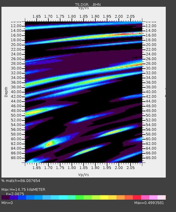
| Estimated Moho Depth: |
14.75 km |
| Estimated Crust Vp/Vs: |
2.09 |
| Assumed Crust Vp: |
6.264 km/s |
| Estimated Crust Vs: |
3.001 km/s |
| Estimated Crust Poisson's Ratio: |
0.35 |
|
| Radial Match: |
86.087654 % |
| Radial Bump: |
378 |
| Transverse Match: |
79.298485 % |
| Transverse Bump: |
400 |
| SOD ConfigId: |
16938 |
| Insert Time: |
2010-02-26 14:07:19.238 +0000 |
| GWidth: |
2.5 |
| Max Bumps: |
400 |
| Tol: |
0.001 |
|

Signal To Noise
| Channel | StoN | STA | LTA |
| TS:DGR: :BHN:19931011T16:05:41.079016Z | 8.952205 | 1.4327512E-6 | 1.6004452E-7 |
| TS:DGR: :BHE:19931011T16:05:41.079016Z | 8.01006 | 1.6944247E-6 | 2.1153706E-7 |
| TS:DGR: :BHZ:19931011T16:05:41.079016Z | 38.42924 | 5.722061E-6 | 1.4889862E-7 |
| Arrivals |
| Ps | 2.6 SECOND |
| PpPs | 7.1 SECOND |
| PsPs/PpSs | 9.7 SECOND |


