You are here: Home > Network List > TJ - Tajikistan National Seismic Network Stations List
> Station GARM Garm, Tajikistan > Earthquake Result Viewer
GARM Garm, Tajikistan - Earthquake Result Viewer
| Earthquake location: |
Off East Coast Of Honshu, Japan |
| Earthquake latitude/longitude: |
36.9/142.4 |
| Earthquake time(UTC): |
2019/03/10 (069) 17:10:52 GMT |
| Earthquake Depth: |
15 km |
| Earthquake Magnitude: |
5.8 Mww |
| Earthquake Catalog/Contributor: |
NEIC PDE/us |
|
| Network: |
TJ Tajikistan National Seismic Network |
| Station: |
GARM Garm, Tajikistan |
| Lat/Lon: |
39.00 N/70.32 E |
| Elevation: |
1305 m |
|
| Distance: |
55.5 deg |
| Az: |
295.862 deg |
| Baz: |
67.865 deg |
| Ray Param: |
0.06476328 |
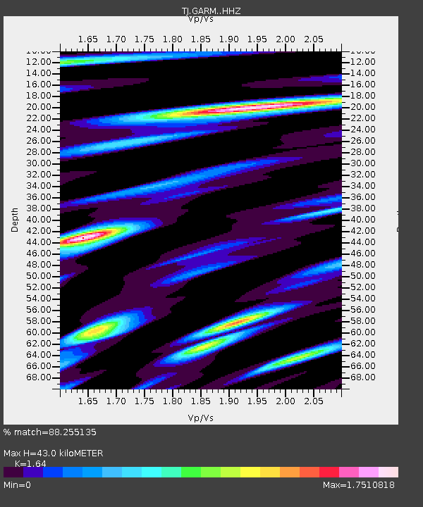
| Estimated Moho Depth: |
43.0 km |
| Estimated Crust Vp/Vs: |
1.64 |
| Assumed Crust Vp: |
6.306 km/s |
| Estimated Crust Vs: |
3.845 km/s |
| Estimated Crust Poisson's Ratio: |
0.20 |
|
| Radial Match: |
88.255135 % |
| Radial Bump: |
390 |
| Transverse Match: |
88.052185 % |
| Transverse Bump: |
376 |
| SOD ConfigId: |
13570011 |
| Insert Time: |
2019-05-02 17:26:59.894 +0000 |
| GWidth: |
2.5 |
| Max Bumps: |
400 |
| Tol: |
0.001 |
|
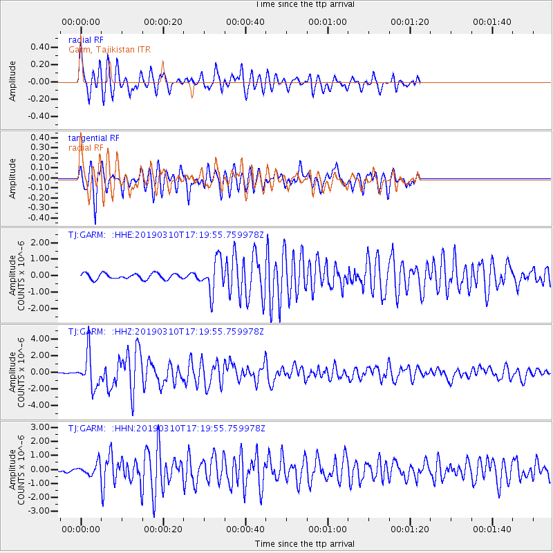
Signal To Noise
| Channel | StoN | STA | LTA |
| TJ:GARM: :HHZ:20190310T17:19:55.759978Z | 11.686301 | 2.1074993E-6 | 1.8033928E-7 |
| TJ:GARM: :HHN:20190310T17:19:55.759978Z | 2.3419244 | 4.3330834E-7 | 1.8502234E-7 |
| TJ:GARM: :HHE:20190310T17:19:55.759978Z | 5.9325175 | 1.03336E-6 | 1.7418574E-7 |
| Arrivals |
| Ps | 4.6 SECOND |
| PpPs | 17 SECOND |
| PsPs/PpSs | 22 SECOND |


