You are here: Home > Network List > TS - TERRAscope (Southern California Seismic Network) Stations List
> Station DGR Domenigoni Valley Reservior, California, USA > Earthquake Result Viewer
DGR Domenigoni Valley Reservior, California, USA - Earthquake Result Viewer
| Earthquake location: |
Peru-Bolivia Border Region |
| Earthquake latitude/longitude: |
-17.5/-69.7 |
| Earthquake time(UTC): |
1994/12/12 (346) 07:41:55 GMT |
| Earthquake Depth: |
151 km |
| Earthquake Magnitude: |
5.8 MB, 6.1 UNKNOWN, 6.3 MW |
| Earthquake Catalog/Contributor: |
WHDF/NEIC |
|
| Network: |
TS TERRAscope (Southern California Seismic Network) |
| Station: |
DGR Domenigoni Valley Reservior, California, USA |
| Lat/Lon: |
33.65 N/117.01 W |
| Elevation: |
700 m |
|
| Distance: |
68.0 deg |
| Az: |
318.569 deg |
| Baz: |
130.798 deg |
| Ray Param: |
0.05616607 |
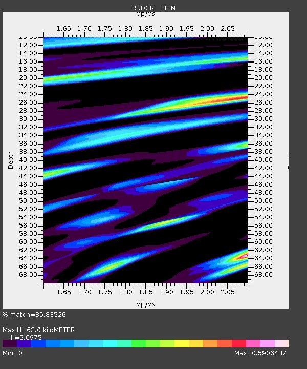
| Estimated Moho Depth: |
63.0 km |
| Estimated Crust Vp/Vs: |
2.10 |
| Assumed Crust Vp: |
6.264 km/s |
| Estimated Crust Vs: |
2.986 km/s |
| Estimated Crust Poisson's Ratio: |
0.35 |
|
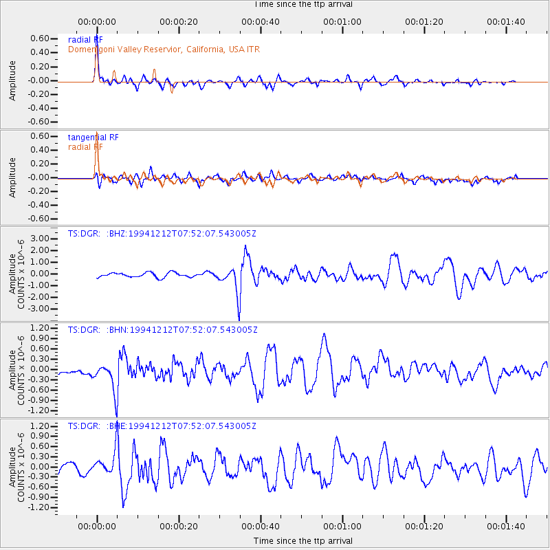
| Radial Match: |
85.83526 % |
| Radial Bump: |
368 |
| Transverse Match: |
61.121574 % |
| Transverse Bump: |
400 |
| SOD ConfigId: |
16938 |
| Insert Time: |
2010-02-26 14:07:20.965 +0000 |
| GWidth: |
2.5 |
| Max Bumps: |
400 |
| Tol: |
0.001 |
|
Signal To Noise
| Channel | StoN | STA | LTA |
| TS:DGR: :BHN:19941212T07:52:07.543005Z | 2.7924685 | 4.6454323E-7 | 1.6635576E-7 |
| TS:DGR: :BHE:19941212T07:52:07.543005Z | 2.52125 | 3.5839184E-7 | 1.4214847E-7 |
| TS:DGR: :BHZ:19941212T07:52:07.543005Z | 5.853639 | 1.1356145E-6 | 1.9400144E-7 |
| Arrivals |
| Ps | 11 SECOND |
| PpPs | 30 SECOND |
| PsPs/PpSs | 42 SECOND |


