You are here: Home > Network List > TA - USArray Transportable Network (new EarthScope stations) Stations List
> Station R11A Troy Canyon, Currant, NV, USA > Earthquake Result Viewer
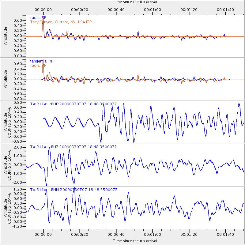
R11A Troy Canyon, Currant, NV, USA - Earthquake Result Viewer

| Earthquake location: |
Kodiak Island Region, Alaska |
| Earthquake latitude/longitude: |
56.5/-152.7 |
| Earthquake time(UTC): |
2009/03/30 (089) 07:13:07 GMT |
| Earthquake Depth: |
21 km |
| Earthquake Magnitude: |
5.9 MB, 5.9 MS, 5.9 MW, 5.9 MW |
| Earthquake Catalog/Contributor: |
WHDF/NEIC |
|
| Network: |
TA USArray Transportable Network (new EarthScope stations) |
| Station: |
R11A Troy Canyon, Currant, NV, USA |
| Lat/Lon: |
38.35 N/115.59 W |
| Elevation: |
1756 m |
|
| Distance: |
30.5 deg |
| Az: |
110.709 deg |
| Baz: |
318.785 deg |
| Ray Param: |
0.079298906 |
| Estimated Moho Depth: |
25.5 km |
| Estimated Crust Vp/Vs: |
1.79 |
| Assumed Crust Vp: |
6.276 km/s |
| Estimated Crust Vs: |
3.506 km/s |
| Estimated Crust Poisson's Ratio: |
0.27 |
|
| Radial Match: |
92.01558 % |
| Radial Bump: |
346 |
| Transverse Match: |
73.86235 % |
| Transverse Bump: |
383 |
| SOD ConfigId: |
2658 |
| Insert Time: |
2010-03-06 20:44:08.847 +0000 |
| GWidth: |
2.5 |
| Max Bumps: |
400 |
| Tol: |
0.001 |
|
Signal To Noise
| Channel | StoN | STA | LTA |
| TA:R11A: :BHZ:20090330T07:18:48.350007Z | 10.167874 | 1.2230654E-6 | 1.2028723E-7 |
| TA:R11A: :BHN:20090330T07:18:48.350007Z | 5.105131 | 6.026362E-7 | 1.18045186E-7 |
| TA:R11A: :BHE:20090330T07:18:48.350007Z | 3.1825256 | 4.431153E-7 | 1.3923386E-7 |
| Arrivals |
| Ps | 3.5 SECOND |
| PpPs | 11 SECOND |
| PsPs/PpSs | 14 SECOND |


