You are here: Home > Network List > TS - TERRAscope (Southern California Seismic Network) Stations List
> Station DGR Domenigoni Valley Reservior, California, USA > Earthquake Result Viewer
DGR Domenigoni Valley Reservior, California, USA - Earthquake Result Viewer
| Earthquake location: |
Peru-Bolivia Border Region |
| Earthquake latitude/longitude: |
-13.3/-69.4 |
| Earthquake time(UTC): |
1994/01/10 (010) 15:53:49 GMT |
| Earthquake Depth: |
589 km |
| Earthquake Magnitude: |
6.4 MB, 6.4 UNKNOWN, 6.9 MW |
| Earthquake Catalog/Contributor: |
WHDF/NEIC |
|
| Network: |
TS TERRAscope (Southern California Seismic Network) |
| Station: |
DGR Domenigoni Valley Reservior, California, USA |
| Lat/Lon: |
33.65 N/117.01 W |
| Elevation: |
700 m |
|
| Distance: |
65.1 deg |
| Az: |
317.204 deg |
| Baz: |
127.545 deg |
| Ray Param: |
0.056306925 |
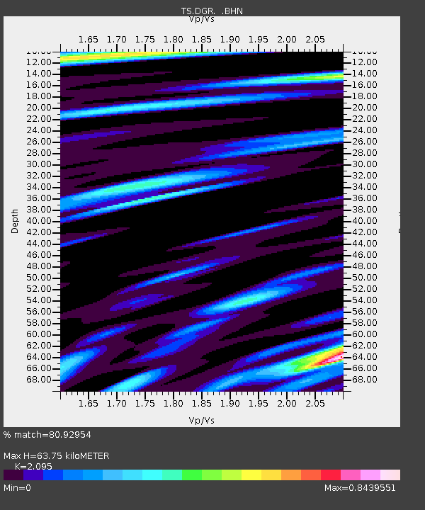
| Estimated Moho Depth: |
63.75 km |
| Estimated Crust Vp/Vs: |
2.10 |
| Assumed Crust Vp: |
6.264 km/s |
| Estimated Crust Vs: |
2.99 km/s |
| Estimated Crust Poisson's Ratio: |
0.35 |
|
| Radial Match: |
80.92954 % |
| Radial Bump: |
400 |
| Transverse Match: |
62.995308 % |
| Transverse Bump: |
400 |
| SOD ConfigId: |
16938 |
| Insert Time: |
2010-02-26 14:07:23.066 +0000 |
| GWidth: |
2.5 |
| Max Bumps: |
400 |
| Tol: |
0.001 |
|
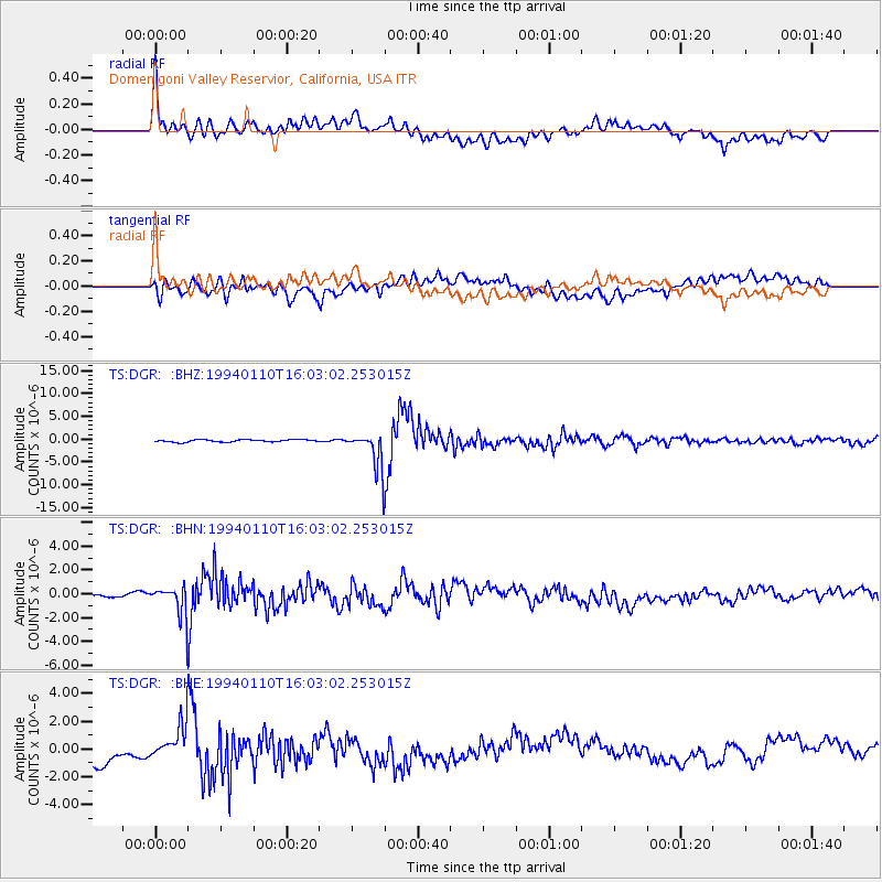
Signal To Noise
| Channel | StoN | STA | LTA |
| TS:DGR: :BHN:19940110T16:03:02.253015Z | 3.3932974 | 1.290714E-6 | 3.8037157E-7 |
| TS:DGR: :BHE:19940110T16:03:02.253015Z | 1.1857212 | 1.2118387E-6 | 1.0220266E-6 |
| TS:DGR: :BHZ:19940110T16:03:02.253015Z | 16.851967 | 4.0471486E-6 | 2.4015884E-7 |
| Arrivals |
| Ps | 11 SECOND |
| PpPs | 31 SECOND |
| PsPs/PpSs | 42 SECOND |


