You are here: Home > Network List > TS - TERRAscope (Southern California Seismic Network) Stations List
> Station DGR Domenigoni Valley Reservior, California, USA > Earthquake Result Viewer
DGR Domenigoni Valley Reservior, California, USA - Earthquake Result Viewer
| Earthquake location: |
Vanuatu Islands |
| Earthquake latitude/longitude: |
-18.8/169.2 |
| Earthquake time(UTC): |
1994/02/11 (042) 21:17:31 GMT |
| Earthquake Depth: |
204 km |
| Earthquake Magnitude: |
6.3 MB, 7.0 UNKNOWN, 6.8 MW |
| Earthquake Catalog/Contributor: |
WHDF/NEIC |
|
| Network: |
TS TERRAscope (Southern California Seismic Network) |
| Station: |
DGR Domenigoni Valley Reservior, California, USA |
| Lat/Lon: |
33.65 N/117.01 W |
| Elevation: |
700 m |
|
| Distance: |
87.5 deg |
| Az: |
53.312 deg |
| Baz: |
245.591 deg |
| Ray Param: |
0.042787846 |
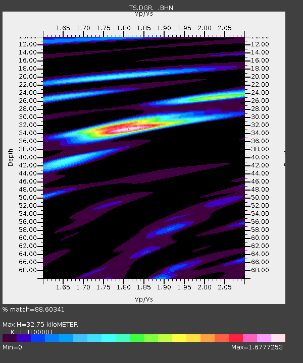
| Estimated Moho Depth: |
32.75 km |
| Estimated Crust Vp/Vs: |
1.81 |
| Assumed Crust Vp: |
6.264 km/s |
| Estimated Crust Vs: |
3.461 km/s |
| Estimated Crust Poisson's Ratio: |
0.28 |
|
| Radial Match: |
88.60341 % |
| Radial Bump: |
400 |
| Transverse Match: |
75.73381 % |
| Transverse Bump: |
400 |
| SOD ConfigId: |
16938 |
| Insert Time: |
2010-02-26 14:07:24.356 +0000 |
| GWidth: |
2.5 |
| Max Bumps: |
400 |
| Tol: |
0.001 |
|

Signal To Noise
| Channel | StoN | STA | LTA |
| TS:DGR: :BHN:19940211T21:29:24.853027Z | 3.6853595 | 8.809157E-7 | 2.3903115E-7 |
| TS:DGR: :BHE:19940211T21:29:24.853027Z | 11.620481 | 2.469877E-6 | 2.1254517E-7 |
| TS:DGR: :BHZ:19940211T21:29:24.853027Z | 24.222574 | 6.8491877E-6 | 2.827605E-7 |
| Arrivals |
| Ps | 4.3 SECOND |
| PpPs | 14 SECOND |
| PsPs/PpSs | 19 SECOND |


