You are here: Home > Network List > TA - USArray Transportable Network (new EarthScope stations) Stations List
> Station R11A Troy Canyon, Currant, NV, USA > Earthquake Result Viewer
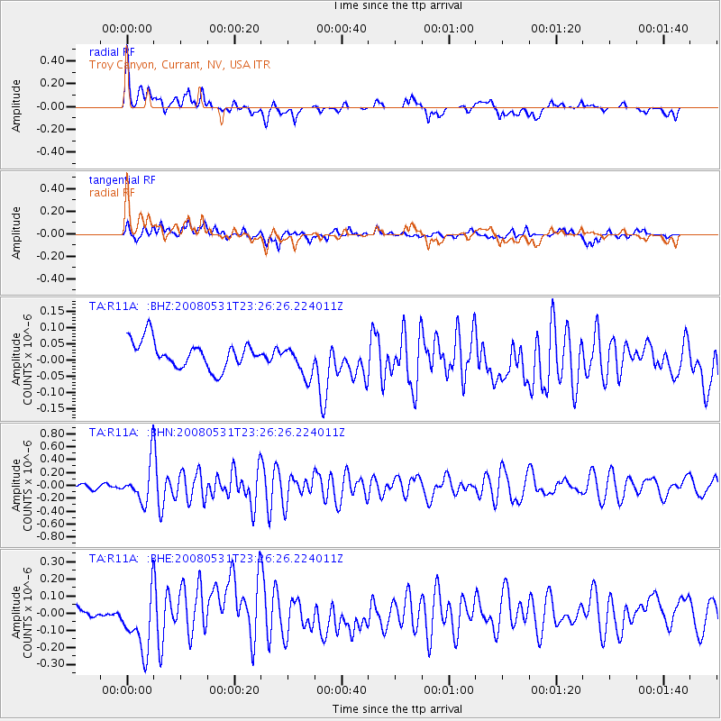
R11A Troy Canyon, Currant, NV, USA - Earthquake Result Viewer
*The percent match for this event was below the threshold and hence no stack was calculated.
| Earthquake location: |
Easter Island Region |
| Earthquake latitude/longitude: |
-28.9/-112.3 |
| Earthquake time(UTC): |
2008/05/31 (152) 23:16:04 GMT |
| Earthquake Depth: |
10 km |
| Earthquake Magnitude: |
5.5 MS, 5.4 MB, 5.8 MW, 5.8 MW |
| Earthquake Catalog/Contributor: |
WHDF/NEIC |
|
| Network: |
TA USArray Transportable Network (new EarthScope stations) |
| Station: |
R11A Troy Canyon, Currant, NV, USA |
| Lat/Lon: |
38.35 N/115.59 W |
| Elevation: |
1756 m |
|
| Distance: |
67.0 deg |
| Az: |
357.158 deg |
| Baz: |
176.831 deg |
| Ray Param: |
$rayparam |
*The percent match for this event was below the threshold and hence was not used in the summary stack. |
|
| Radial Match: |
74.35061 % |
| Radial Bump: |
400 |
| Transverse Match: |
67.30591 % |
| Transverse Bump: |
400 |
| SOD ConfigId: |
2504 |
| Insert Time: |
2010-03-06 20:44:49.815 +0000 |
| GWidth: |
2.5 |
| Max Bumps: |
400 |
| Tol: |
0.001 |
|
Signal To Noise
| Channel | StoN | STA | LTA |
| TA:R11A: :BHN:20080531T23:26:26.224011Z | 5.940526 | 3.058208E-7 | 5.1480427E-8 |
| TA:R11A: :BHE:20080531T23:26:26.224011Z | 5.826492 | 1.7397146E-7 | 2.9858697E-8 |
| TA:R11A: :BHZ:20080531T23:26:26.224011Z | 1.2349274 | 5.1022436E-8 | 4.1316138E-8 |
| Arrivals |
| Ps | |
| PpPs | |
| PsPs/PpSs | |


