You are here: Home > Network List > TA - USArray Transportable Network (new EarthScope stations) Stations List
> Station E18K Tukpahlearik Creek, AK, USA > Earthquake Result Viewer
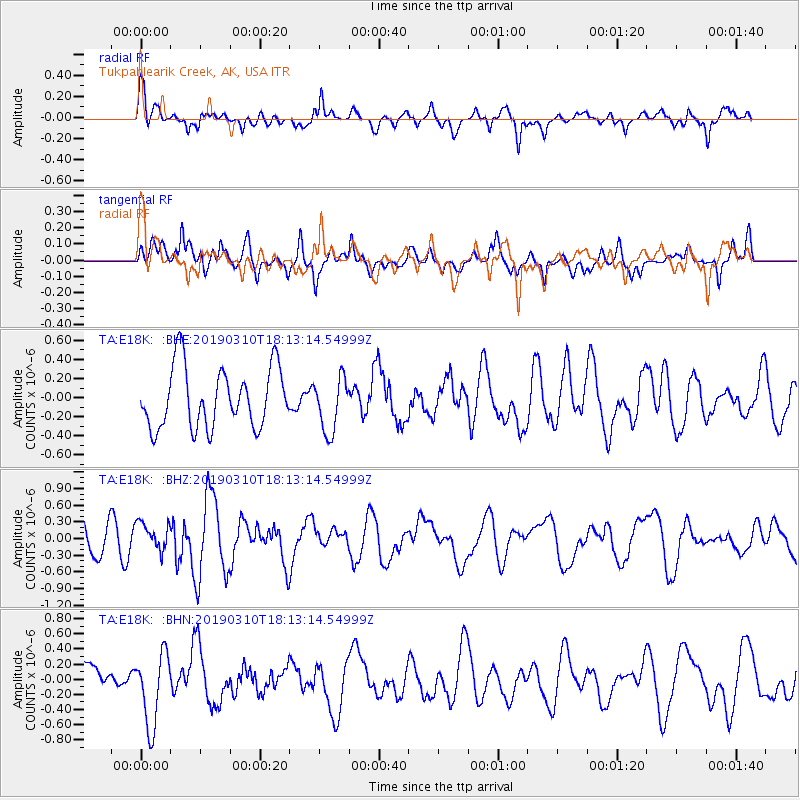
E18K Tukpahlearik Creek, AK, USA - Earthquake Result Viewer
*The percent match for this event was below the threshold and hence no stack was calculated.
| Earthquake location: |
Reykjanes Ridge |
| Earthquake latitude/longitude: |
58.3/-32.0 |
| Earthquake time(UTC): |
2019/03/10 (069) 18:04:59 GMT |
| Earthquake Depth: |
10 km |
| Earthquake Magnitude: |
5.9 Mww |
| Earthquake Catalog/Contributor: |
NEIC PDE/us |
|
| Network: |
TA USArray Transportable Network (new EarthScope stations) |
| Station: |
E18K Tukpahlearik Creek, AK, USA |
| Lat/Lon: |
67.42 N/160.60 W |
| Elevation: |
297 m |
|
| Distance: |
49.0 deg |
| Az: |
336.433 deg |
| Baz: |
33.101 deg |
| Ray Param: |
$rayparam |
*The percent match for this event was below the threshold and hence was not used in the summary stack. |
|
| Radial Match: |
68.44994 % |
| Radial Bump: |
385 |
| Transverse Match: |
65.97662 % |
| Transverse Bump: |
400 |
| SOD ConfigId: |
13570011 |
| Insert Time: |
2019-05-02 17:41:50.315 +0000 |
| GWidth: |
2.5 |
| Max Bumps: |
400 |
| Tol: |
0.001 |
|
Signal To Noise
| Channel | StoN | STA | LTA |
| TA:E18K: :BHZ:20190310T18:13:14.54999Z | 0.86528677 | 2.5003703E-7 | 2.8896437E-7 |
| TA:E18K: :BHN:20190310T18:13:14.54999Z | 2.1935992 | 4.793352E-7 | 2.185154E-7 |
| TA:E18K: :BHE:20190310T18:13:14.54999Z | 0.90453595 | 2.8522703E-7 | 3.1532966E-7 |
| Arrivals |
| Ps | |
| PpPs | |
| PsPs/PpSs | |


