You are here: Home > Network List > TA - USArray Transportable Network (new EarthScope stations) Stations List
> Station L15K Ungalak Mountain, AK, USA > Earthquake Result Viewer
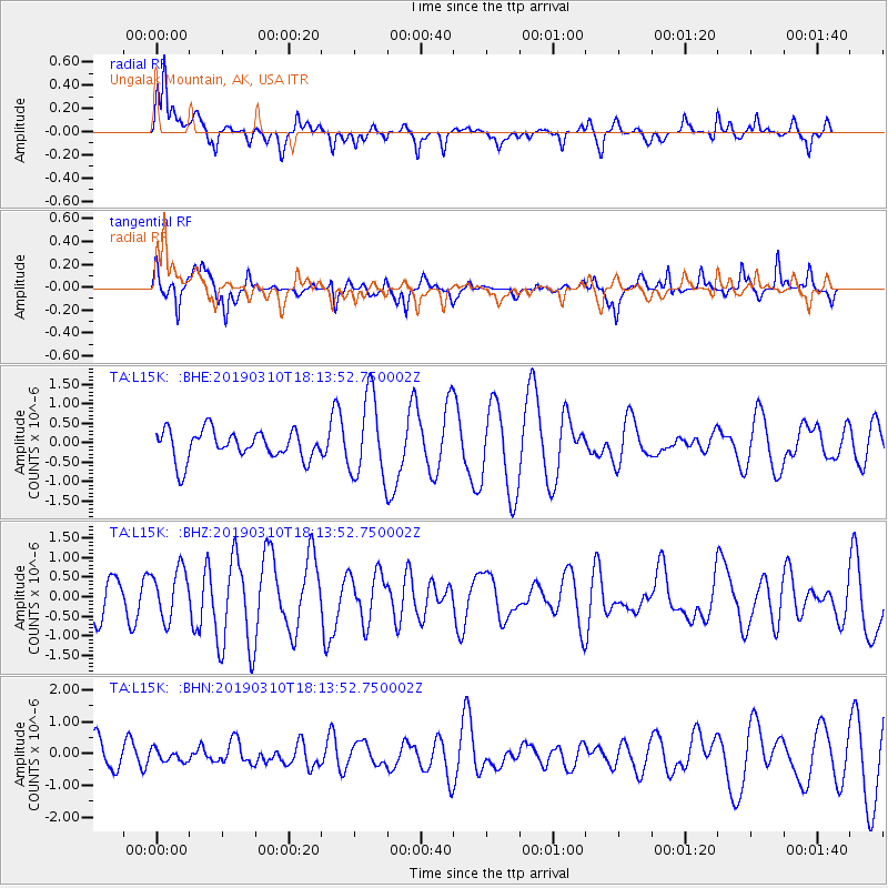
L15K Ungalak Mountain, AK, USA - Earthquake Result Viewer
*The percent match for this event was below the threshold and hence no stack was calculated.
| Earthquake location: |
Reykjanes Ridge |
| Earthquake latitude/longitude: |
58.3/-32.0 |
| Earthquake time(UTC): |
2019/03/10 (069) 18:04:59 GMT |
| Earthquake Depth: |
10 km |
| Earthquake Magnitude: |
5.9 Mww |
| Earthquake Catalog/Contributor: |
NEIC PDE/us |
|
| Network: |
TA USArray Transportable Network (new EarthScope stations) |
| Station: |
L15K Ungalak Mountain, AK, USA |
| Lat/Lon: |
61.68 N/161.49 W |
| Elevation: |
219 m |
|
| Distance: |
54.1 deg |
| Az: |
332.987 deg |
| Baz: |
30.156 deg |
| Ray Param: |
$rayparam |
*The percent match for this event was below the threshold and hence was not used in the summary stack. |
|
| Radial Match: |
71.36285 % |
| Radial Bump: |
398 |
| Transverse Match: |
68.37955 % |
| Transverse Bump: |
327 |
| SOD ConfigId: |
13570011 |
| Insert Time: |
2019-05-02 17:42:03.162 +0000 |
| GWidth: |
2.5 |
| Max Bumps: |
400 |
| Tol: |
0.001 |
|
Signal To Noise
| Channel | StoN | STA | LTA |
| TA:L15K: :BHZ:20190310T18:13:52.750002Z | 1.1239002 | 6.355908E-7 | 5.655225E-7 |
| TA:L15K: :BHN:20190310T18:13:52.750002Z | 0.28926712 | 1.8332854E-7 | 6.33769E-7 |
| TA:L15K: :BHE:20190310T18:13:52.750002Z | 2.8209825 | 1.0542443E-6 | 3.737153E-7 |
| Arrivals |
| Ps | |
| PpPs | |
| PsPs/PpSs | |


