You are here: Home > Network List > TS - TERRAscope (Southern California Seismic Network) Stations List
> Station DGR Domenigoni Valley Reservior, California, USA > Earthquake Result Viewer
DGR Domenigoni Valley Reservior, California, USA - Earthquake Result Viewer

| Earthquake location: |
South Pacific Ocean |
| Earthquake latitude/longitude: |
-10.8/-128.8 |
| Earthquake time(UTC): |
1994/02/12 (043) 04:16:26 GMT |
| Earthquake Depth: |
10 km |
| Earthquake Magnitude: |
6.3 MB, 6.5 MS, 6.6 UNKNOWN, 6.6 MW |
| Earthquake Catalog/Contributor: |
WHDF/NEIC |
|
| Network: |
TS TERRAscope (Southern California Seismic Network) |
| Station: |
DGR Domenigoni Valley Reservior, California, USA |
| Lat/Lon: |
33.65 N/117.01 W |
| Elevation: |
700 m |
|
| Distance: |
45.6 deg |
| Az: |
13.836 deg |
| Baz: |
196.362 deg |
| Ray Param: |
0.07117788 |
| Estimated Moho Depth: |
35.0 km |
| Estimated Crust Vp/Vs: |
1.83 |
| Assumed Crust Vp: |
6.264 km/s |
| Estimated Crust Vs: |
3.427 km/s |
| Estimated Crust Poisson's Ratio: |
0.29 |
|
| Radial Match: |
85.418304 % |
| Radial Bump: |
400 |
| Transverse Match: |
57.189594 % |
| Transverse Bump: |
400 |
| SOD ConfigId: |
16938 |
| Insert Time: |
2010-02-26 14:07:25.611 +0000 |
| GWidth: |
2.5 |
| Max Bumps: |
400 |
| Tol: |
0.001 |
|
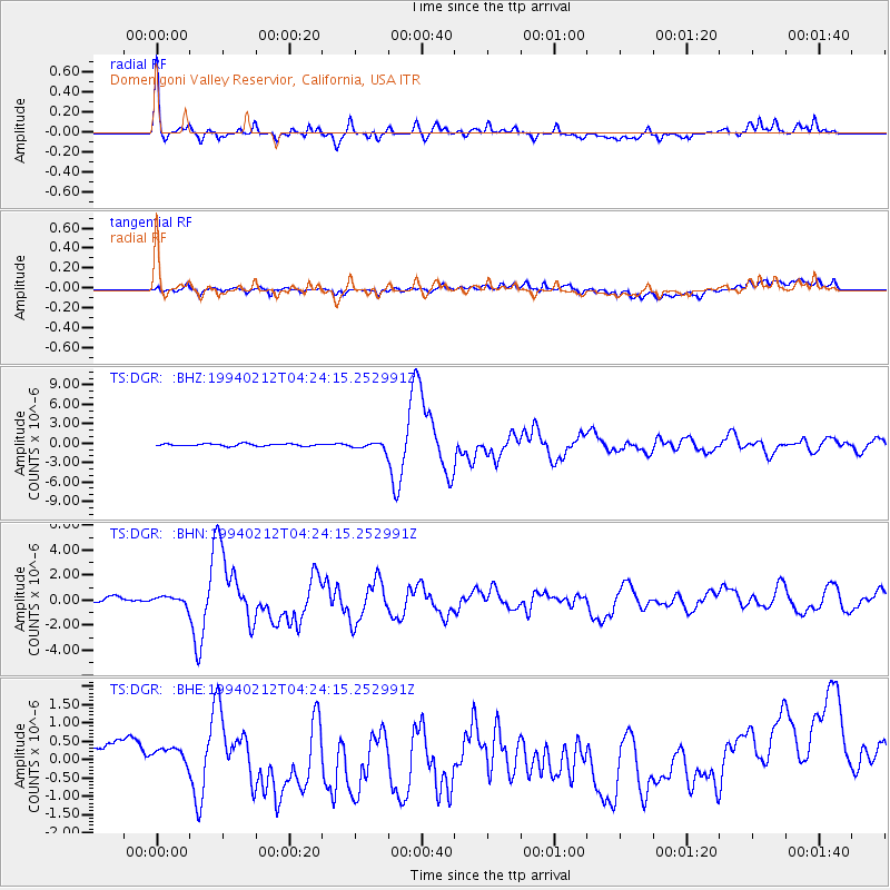
Signal To Noise
| Channel | StoN | STA | LTA |
| TS:DGR: :BHN:19940212T04:24:15.252991Z | 1.455956 | 4.272577E-7 | 2.9345512E-7 |
| TS:DGR: :BHE:19940212T04:24:15.252991Z | 0.6362989 | 1.9591145E-7 | 3.0789218E-7 |
| TS:DGR: :BHZ:19940212T04:24:15.252991Z | 2.915479 | 5.1134356E-7 | 1.753892E-7 |
| Arrivals |
| Ps | 4.9 SECOND |
| PpPs | 15 SECOND |
| PsPs/PpSs | 20 SECOND |


