You are here: Home > Network List > TA - USArray Transportable Network (new EarthScope stations) Stations List
> Station R11A Troy Canyon, Currant, NV, USA > Earthquake Result Viewer
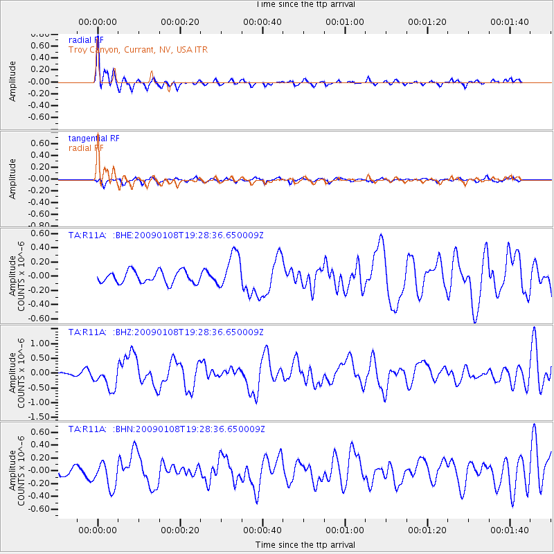
R11A Troy Canyon, Currant, NV, USA - Earthquake Result Viewer
*The percent match for this event was below the threshold and hence no stack was calculated.
| Earthquake location: |
Costa Rica |
| Earthquake latitude/longitude: |
10.2/-84.2 |
| Earthquake time(UTC): |
2009/01/08 (008) 19:21:35 GMT |
| Earthquake Depth: |
14 km |
| Earthquake Magnitude: |
5.7 MB, 6.0 MS, 6.1 MW, 6.1 MW |
| Earthquake Catalog/Contributor: |
WHDF/NEIC |
|
| Network: |
TA USArray Transportable Network (new EarthScope stations) |
| Station: |
R11A Troy Canyon, Currant, NV, USA |
| Lat/Lon: |
38.35 N/115.59 W |
| Elevation: |
1756 m |
|
| Distance: |
39.7 deg |
| Az: |
320.149 deg |
| Baz: |
126.644 deg |
| Ray Param: |
$rayparam |
*The percent match for this event was below the threshold and hence was not used in the summary stack. |
|
| Radial Match: |
78.34276 % |
| Radial Bump: |
347 |
| Transverse Match: |
51.02526 % |
| Transverse Bump: |
389 |
| SOD ConfigId: |
2834 |
| Insert Time: |
2010-03-06 20:45:19.957 +0000 |
| GWidth: |
2.5 |
| Max Bumps: |
400 |
| Tol: |
0.001 |
|
Signal To Noise
| Channel | StoN | STA | LTA |
| TA:R11A: :BHZ:20090108T19:28:36.650009Z | 4.3638277 | 3.8672948E-7 | 8.8621626E-8 |
| TA:R11A: :BHN:20090108T19:28:36.650009Z | 2.5575247 | 2.0320428E-7 | 7.945349E-8 |
| TA:R11A: :BHE:20090108T19:28:36.650009Z | 3.0727987 | 2.5730478E-7 | 8.3736296E-8 |
| Arrivals |
| Ps | |
| PpPs | |
| PsPs/PpSs | |


