You are here: Home > Network List > TA - USArray Transportable Network (new EarthScope stations) Stations List
> Station R33M Jennings River, BC, CAN > Earthquake Result Viewer
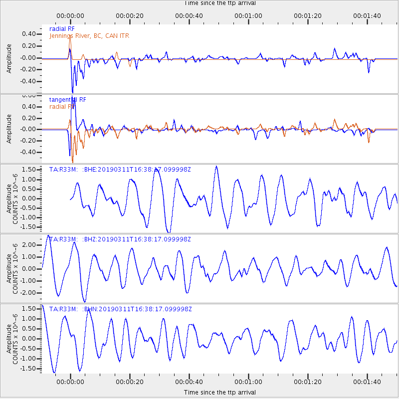
R33M Jennings River, BC, CAN - Earthquake Result Viewer
*The percent match for this event was below the threshold and hence no stack was calculated.
| Earthquake location: |
New Britain Region, P.N.G. |
| Earthquake latitude/longitude: |
-6.1/149.0 |
| Earthquake time(UTC): |
2019/03/11 (070) 16:25:51 GMT |
| Earthquake Depth: |
31 km |
| Earthquake Magnitude: |
5.8 Mww |
| Earthquake Catalog/Contributor: |
NEIC PDE/us |
|
| Network: |
TA USArray Transportable Network (new EarthScope stations) |
| Station: |
R33M Jennings River, BC, CAN |
| Lat/Lon: |
59.39 N/130.97 W |
| Elevation: |
1437 m |
|
| Distance: |
90.1 deg |
| Az: |
30.261 deg |
| Baz: |
258.375 deg |
| Ray Param: |
$rayparam |
*The percent match for this event was below the threshold and hence was not used in the summary stack. |
|
| Radial Match: |
81.7987 % |
| Radial Bump: |
400 |
| Transverse Match: |
87.794754 % |
| Transverse Bump: |
400 |
| SOD ConfigId: |
13570011 |
| Insert Time: |
2019-05-02 17:51:11.248 +0000 |
| GWidth: |
2.5 |
| Max Bumps: |
400 |
| Tol: |
0.001 |
|
Signal To Noise
| Channel | StoN | STA | LTA |
| TA:R33M: :BHZ:20190311T16:38:17.099998Z | 1.3988787 | 1.6317902E-6 | 1.1664988E-6 |
| TA:R33M: :BHN:20190311T16:38:17.099998Z | 1.1013131 | 8.5115937E-7 | 7.728587E-7 |
| TA:R33M: :BHE:20190311T16:38:17.099998Z | 2.2412906 | 1.260374E-6 | 5.62343E-7 |
| Arrivals |
| Ps | |
| PpPs | |
| PsPs/PpSs | |


