You are here: Home > Network List > TA - USArray Transportable Network (new EarthScope stations) Stations List
> Station R11A Troy Canyon, Currant, NV, USA > Earthquake Result Viewer
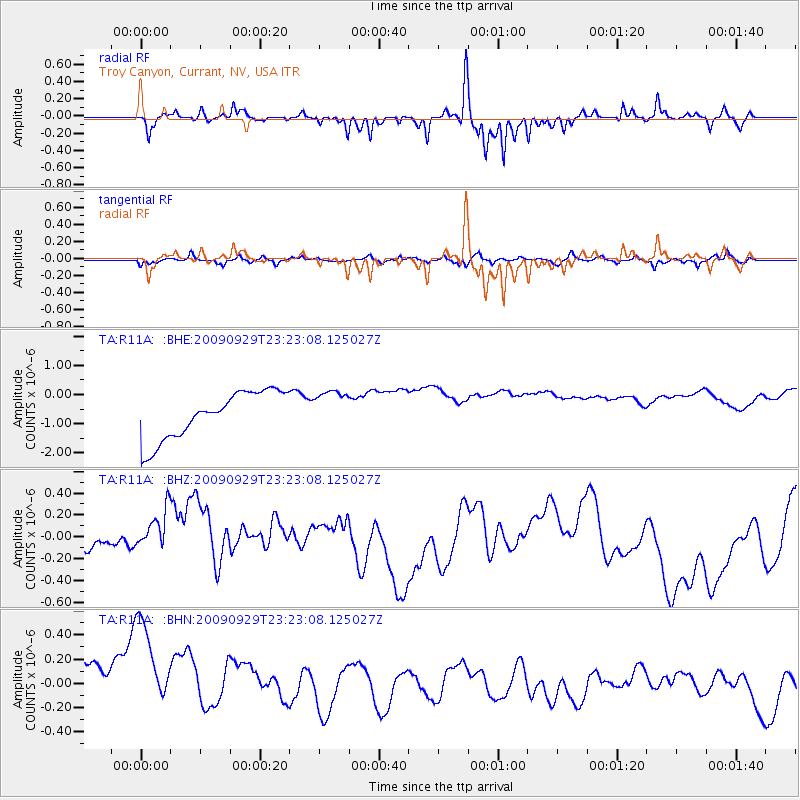
R11A Troy Canyon, Currant, NV, USA - Earthquake Result Viewer
*The percent match for this event was below the threshold and hence no stack was calculated.
| Earthquake location: |
Tonga Islands |
| Earthquake latitude/longitude: |
-15.6/-173.4 |
| Earthquake time(UTC): |
2009/09/29 (272) 23:11:51 GMT |
| Earthquake Depth: |
10 km |
| Earthquake Magnitude: |
5.5 MB |
| Earthquake Catalog/Contributor: |
WHDF/NEIC |
|
| Network: |
TA USArray Transportable Network (new EarthScope stations) |
| Station: |
R11A Troy Canyon, Currant, NV, USA |
| Lat/Lon: |
38.35 N/115.59 W |
| Elevation: |
1756 m |
|
| Distance: |
76.2 deg |
| Az: |
43.239 deg |
| Baz: |
237.091 deg |
| Ray Param: |
$rayparam |
*The percent match for this event was below the threshold and hence was not used in the summary stack. |
|
| Radial Match: |
78.65608 % |
| Radial Bump: |
328 |
| Transverse Match: |
60.60878 % |
| Transverse Bump: |
399 |
| SOD ConfigId: |
2622 |
| Insert Time: |
2010-03-06 20:45:30.849 +0000 |
| GWidth: |
2.5 |
| Max Bumps: |
400 |
| Tol: |
0.001 |
|
Signal To Noise
| Channel | StoN | STA | LTA |
| TA:R11A: :BHZ:20090929T23:23:08.125027Z | 1.1432005 | 2.717136E-7 | 2.3767797E-7 |
| TA:R11A: :BHN:20090929T23:23:08.125027Z | 1.2464399 | 7.888724E-7 | 6.329005E-7 |
| TA:R11A: :BHE:20090929T23:23:08.125027Z | 0.8607524 | 6.9653424E-7 | 8.092155E-7 |
| Arrivals |
| Ps | |
| PpPs | |
| PsPs/PpSs | |


