You are here: Home > Network List > TS - TERRAscope (Southern California Seismic Network) Stations List
> Station DGR Domenigoni Valley Reservior, California, USA > Earthquake Result Viewer
DGR Domenigoni Valley Reservior, California, USA - Earthquake Result Viewer
| Earthquake location: |
Fiji Islands Region |
| Earthquake latitude/longitude: |
-17.8/-178.5 |
| Earthquake time(UTC): |
1994/03/09 (068) 23:28:07 GMT |
| Earthquake Depth: |
564 km |
| Earthquake Magnitude: |
6.6 MB, 7.6 UNKNOWN, 7.6 MW |
| Earthquake Catalog/Contributor: |
WHDF/NEIC |
|
| Network: |
TS TERRAscope (Southern California Seismic Network) |
| Station: |
DGR Domenigoni Valley Reservior, California, USA |
| Lat/Lon: |
33.65 N/117.01 W |
| Elevation: |
700 m |
|
| Distance: |
77.8 deg |
| Az: |
48.597 deg |
| Baz: |
238.966 deg |
| Ray Param: |
0.048349928 |
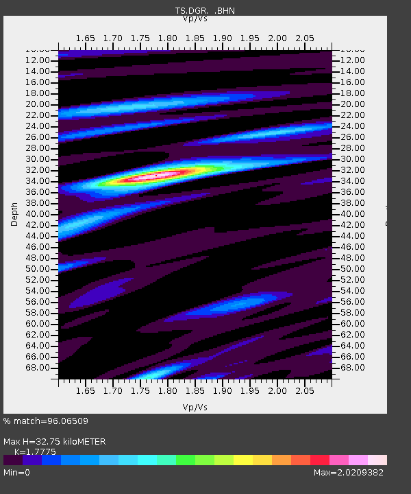
| Estimated Moho Depth: |
32.75 km |
| Estimated Crust Vp/Vs: |
1.78 |
| Assumed Crust Vp: |
6.264 km/s |
| Estimated Crust Vs: |
3.524 km/s |
| Estimated Crust Poisson's Ratio: |
0.27 |
|
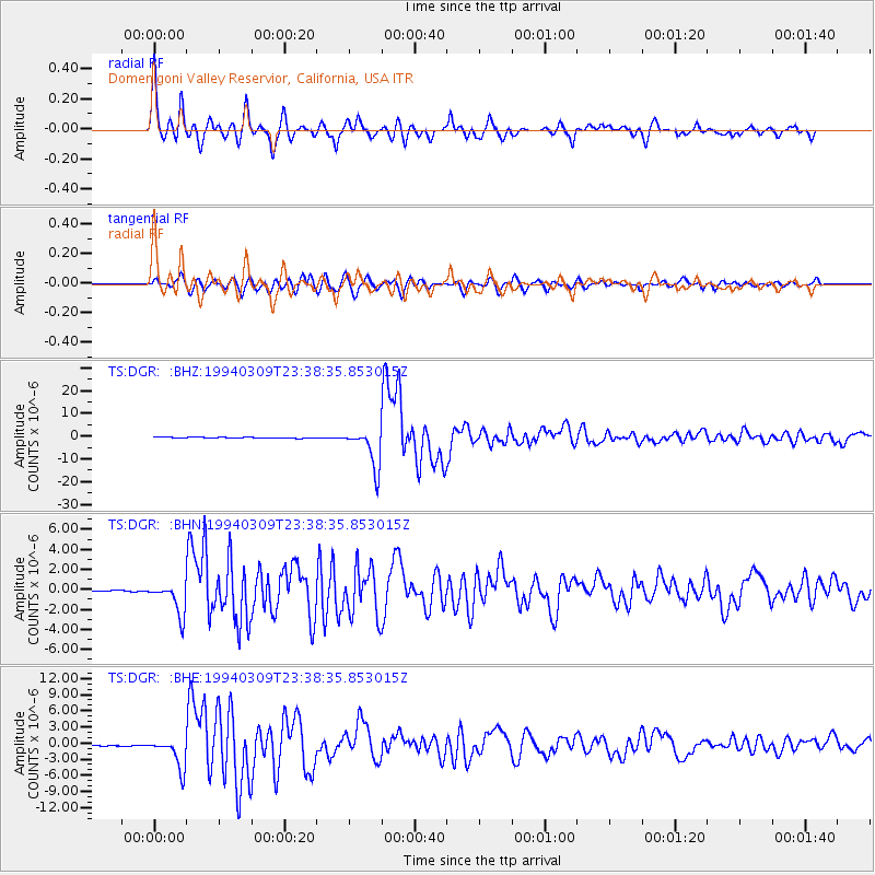
| Radial Match: |
96.06509 % |
| Radial Bump: |
350 |
| Transverse Match: |
90.06192 % |
| Transverse Bump: |
400 |
| SOD ConfigId: |
16938 |
| Insert Time: |
2010-02-26 14:07:28.394 +0000 |
| GWidth: |
2.5 |
| Max Bumps: |
400 |
| Tol: |
0.001 |
|
Signal To Noise
| Channel | StoN | STA | LTA |
| TS:DGR: :BHN:19940309T23:38:35.853015Z | 23.443901 | 1.6077444E-6 | 6.857836E-8 |
| TS:DGR: :BHE:19940309T23:38:35.853015Z | 21.082663 | 2.8707038E-6 | 1.361642E-7 |
| TS:DGR: :BHZ:19940309T23:38:35.853015Z | 49.03555 | 8.610441E-6 | 1.755959E-7 |
| Arrivals |
| Ps | 4.2 SECOND |
| PpPs | 14 SECOND |
| PsPs/PpSs | 18 SECOND |


