You are here: Home > Network List > TA - USArray Transportable Network (new EarthScope stations) Stations List
> Station D25K Kavik River, AK, USA > Earthquake Result Viewer
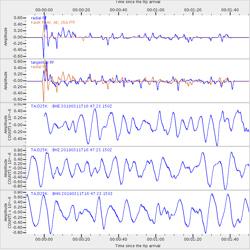
D25K Kavik River, AK, USA - Earthquake Result Viewer
*The percent match for this event was below the threshold and hence no stack was calculated.
| Earthquake location: |
Northern Sumatra, Indonesia |
| Earthquake latitude/longitude: |
1.2/98.8 |
| Earthquake time(UTC): |
2019/03/11 (070) 16:34:28 GMT |
| Earthquake Depth: |
73 km |
| Earthquake Magnitude: |
5.4 Mww |
| Earthquake Catalog/Contributor: |
NEIC PDE/us |
|
| Network: |
TA USArray Transportable Network (new EarthScope stations) |
| Station: |
D25K Kavik River, AK, USA |
| Lat/Lon: |
69.32 N/146.38 W |
| Elevation: |
770 m |
|
| Distance: |
97.5 deg |
| Az: |
18.972 deg |
| Baz: |
293.776 deg |
| Ray Param: |
$rayparam |
*The percent match for this event was below the threshold and hence was not used in the summary stack. |
|
| Radial Match: |
66.20439 % |
| Radial Bump: |
400 |
| Transverse Match: |
79.24212 % |
| Transverse Bump: |
379 |
| SOD ConfigId: |
13570011 |
| Insert Time: |
2019-05-02 17:54:18.081 +0000 |
| GWidth: |
2.5 |
| Max Bumps: |
400 |
| Tol: |
0.001 |
|
Signal To Noise
| Channel | StoN | STA | LTA |
| TA:D25K: :BHZ:20190311T16:47:23.150Z | 1.6697618 | 4.5016685E-7 | 2.6959944E-7 |
| TA:D25K: :BHN:20190311T16:47:23.150Z | 1.732324 | 5.5397254E-7 | 3.1978576E-7 |
| TA:D25K: :BHE:20190311T16:47:23.150Z | 1.0249082 | 2.0501953E-7 | 2.0003696E-7 |
| Arrivals |
| Ps | |
| PpPs | |
| PsPs/PpSs | |


