You are here: Home > Network List > TA - USArray Transportable Network (new EarthScope stations) Stations List
> Station R11A Troy Canyon, Currant, NV, USA > Earthquake Result Viewer
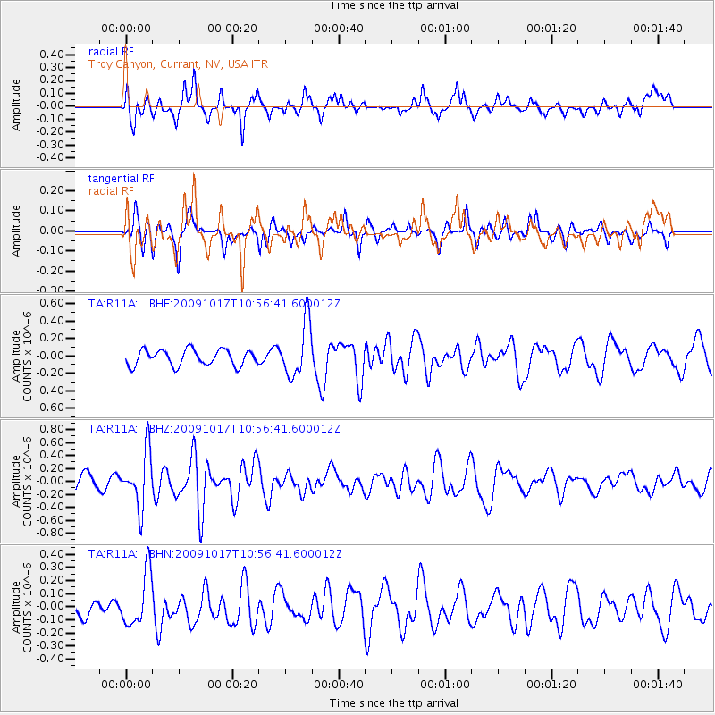
R11A Troy Canyon, Currant, NV, USA - Earthquake Result Viewer
*The percent match for this event was below the threshold and hence no stack was calculated.
| Earthquake location: |
Samoa Islands Region |
| Earthquake latitude/longitude: |
-16.4/-172.0 |
| Earthquake time(UTC): |
2009/10/17 (290) 10:45:26 GMT |
| Earthquake Depth: |
10 km |
| Earthquake Magnitude: |
5.7 MB, 5.3 MS, 5.7 MW, 5.7 MW |
| Earthquake Catalog/Contributor: |
WHDF/NEIC |
|
| Network: |
TA USArray Transportable Network (new EarthScope stations) |
| Station: |
R11A Troy Canyon, Currant, NV, USA |
| Lat/Lon: |
38.35 N/115.59 W |
| Elevation: |
1756 m |
|
| Distance: |
75.8 deg |
| Az: |
42.488 deg |
| Baz: |
235.556 deg |
| Ray Param: |
$rayparam |
*The percent match for this event was below the threshold and hence was not used in the summary stack. |
|
| Radial Match: |
56.162544 % |
| Radial Bump: |
400 |
| Transverse Match: |
51.888916 % |
| Transverse Bump: |
315 |
| SOD ConfigId: |
2622 |
| Insert Time: |
2010-03-06 20:45:38.071 +0000 |
| GWidth: |
2.5 |
| Max Bumps: |
400 |
| Tol: |
0.001 |
|
Signal To Noise
| Channel | StoN | STA | LTA |
| TA:R11A: :BHZ:20091017T10:56:41.600012Z | 3.2822251 | 4.3598578E-7 | 1.3283238E-7 |
| TA:R11A: :BHN:20091017T10:56:41.600012Z | 1.7355325 | 2.0674341E-7 | 1.1912391E-7 |
| TA:R11A: :BHE:20091017T10:56:41.600012Z | 3.4852443 | 3.1387592E-7 | 9.0058506E-8 |
| Arrivals |
| Ps | |
| PpPs | |
| PsPs/PpSs | |


