You are here: Home > Network List > TA - USArray Transportable Network (new EarthScope stations) Stations List
> Station R11A Troy Canyon, Currant, NV, USA > Earthquake Result Viewer
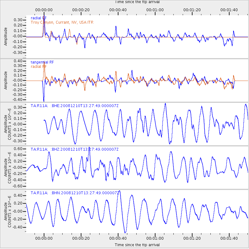
R11A Troy Canyon, Currant, NV, USA - Earthquake Result Viewer
*The percent match for this event was below the threshold and hence no stack was calculated.
| Earthquake location: |
Santa Cruz Islands |
| Earthquake latitude/longitude: |
-12.3/166.6 |
| Earthquake time(UTC): |
2008/12/10 (345) 13:15:34 GMT |
| Earthquake Depth: |
51 km |
| Earthquake Magnitude: |
5.7 MB, 6.0 MW, 6.0 MW |
| Earthquake Catalog/Contributor: |
WHDF/NEIC |
|
| Network: |
TA USArray Transportable Network (new EarthScope stations) |
| Station: |
R11A Troy Canyon, Currant, NV, USA |
| Lat/Lon: |
38.35 N/115.59 W |
| Elevation: |
1756 m |
|
| Distance: |
88.2 deg |
| Az: |
50.264 deg |
| Baz: |
252.889 deg |
| Ray Param: |
$rayparam |
*The percent match for this event was below the threshold and hence was not used in the summary stack. |
|
| Radial Match: |
44.83117 % |
| Radial Bump: |
400 |
| Transverse Match: |
33.082054 % |
| Transverse Bump: |
400 |
| SOD ConfigId: |
2658 |
| Insert Time: |
2010-03-06 20:45:53.790 +0000 |
| GWidth: |
2.5 |
| Max Bumps: |
400 |
| Tol: |
0.001 |
|
Signal To Noise
| Channel | StoN | STA | LTA |
| TA:R11A: :BHZ:20081210T13:27:49.000007Z | 2.8263395 | 2.5640543E-7 | 9.071997E-8 |
| TA:R11A: :BHN:20081210T13:27:49.000007Z | 1.2791786 | 1.831684E-7 | 1.431922E-7 |
| TA:R11A: :BHE:20081210T13:27:49.000007Z | 1.2855752 | 1.9310737E-7 | 1.5021088E-7 |
| Arrivals |
| Ps | |
| PpPs | |
| PsPs/PpSs | |


