You are here: Home > Network List > TS - TERRAscope (Southern California Seismic Network) Stations List
> Station DGR Domenigoni Valley Reservior, California, USA > Earthquake Result Viewer
DGR Domenigoni Valley Reservior, California, USA - Earthquake Result Viewer
| Earthquake location: |
Solomon Islands |
| Earthquake latitude/longitude: |
-6.5/154.9 |
| Earthquake time(UTC): |
1994/04/18 (108) 17:29:56 GMT |
| Earthquake Depth: |
43 km |
| Earthquake Magnitude: |
6.6 MB, 6.7 MS, 6.8 UNKNOWN, 6.7 MW |
| Earthquake Catalog/Contributor: |
WHDF/NEIC |
|
| Network: |
TS TERRAscope (Southern California Seismic Network) |
| Station: |
DGR Domenigoni Valley Reservior, California, USA |
| Lat/Lon: |
33.65 N/117.01 W |
| Elevation: |
700 m |
|
| Distance: |
92.0 deg |
| Az: |
56.529 deg |
| Baz: |
263.566 deg |
| Ray Param: |
0.041518956 |
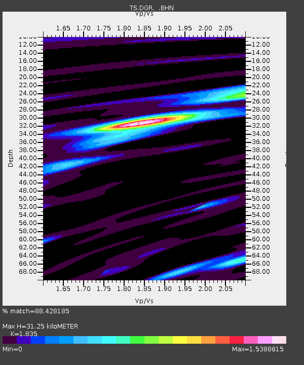
| Estimated Moho Depth: |
31.25 km |
| Estimated Crust Vp/Vs: |
1.84 |
| Assumed Crust Vp: |
6.264 km/s |
| Estimated Crust Vs: |
3.413 km/s |
| Estimated Crust Poisson's Ratio: |
0.29 |
|
| Radial Match: |
88.428185 % |
| Radial Bump: |
400 |
| Transverse Match: |
83.46452 % |
| Transverse Bump: |
400 |
| SOD ConfigId: |
16938 |
| Insert Time: |
2010-02-26 14:07:30.681 +0000 |
| GWidth: |
2.5 |
| Max Bumps: |
400 |
| Tol: |
0.001 |
|
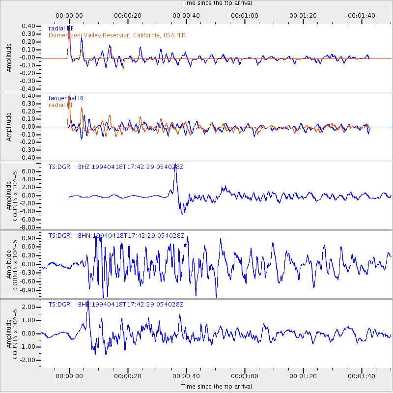
Signal To Noise
| Channel | StoN | STA | LTA |
| TS:DGR: :BHN:19940418T17:42:29.054028Z | 1.1717042 | 7.9085694E-8 | 6.74963E-8 |
| TS:DGR: :BHE:19940418T17:42:29.054028Z | 2.6442606 | 3.6038088E-7 | 1.3628795E-7 |
| TS:DGR: :BHZ:19940418T17:42:29.054028Z | 2.5697155 | 5.487128E-7 | 2.1353057E-7 |
| Arrivals |
| Ps | 4.2 SECOND |
| PpPs | 14 SECOND |
| PsPs/PpSs | 18 SECOND |


