You are here: Home > Network List > TA - USArray Transportable Network (new EarthScope stations) Stations List
> Station Z27A Tatum, NM, USA > Earthquake Result Viewer
Z27A Tatum, NM, USA - Earthquake Result Viewer

| Earthquake location: |
Kuril Islands |
| Earthquake latitude/longitude: |
51.0/157.6 |
| Earthquake time(UTC): |
2008/07/24 (206) 01:43:16 GMT |
| Earthquake Depth: |
27 km |
| Earthquake Magnitude: |
6.0 MB, 6.0 MS, 6.2 MW, 6.2 MW |
| Earthquake Catalog/Contributor: |
WHDF/NEIC |
|
| Network: |
TA USArray Transportable Network (new EarthScope stations) |
| Station: |
Z27A Tatum, NM, USA |
| Lat/Lon: |
33.31 N/103.21 W |
| Elevation: |
1197 m |
|
| Distance: |
70.2 deg |
| Az: |
61.468 deg |
| Baz: |
318.438 deg |
| Ray Param: |
0.0551086 |
| Estimated Moho Depth: |
37.0 km |
| Estimated Crust Vp/Vs: |
1.91 |
| Assumed Crust Vp: |
6.129 km/s |
| Estimated Crust Vs: |
3.205 km/s |
| Estimated Crust Poisson's Ratio: |
0.31 |
|
| Radial Match: |
89.615746 % |
| Radial Bump: |
397 |
| Transverse Match: |
72.43552 % |
| Transverse Bump: |
400 |
| SOD ConfigId: |
2504 |
| Insert Time: |
2010-03-06 20:46:41.684 +0000 |
| GWidth: |
2.5 |
| Max Bumps: |
400 |
| Tol: |
0.001 |
|
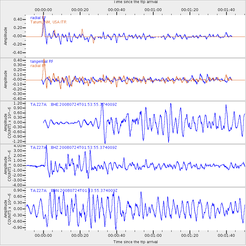
Signal To Noise
| Channel | StoN | STA | LTA |
| TA:Z27A: :BHZ:20080724T01:53:55.374009Z | 14.141299 | 1.5979717E-6 | 1.1300035E-7 |
| TA:Z27A: :BHN:20080724T01:53:55.374009Z | 3.1081784 | 4.6682996E-7 | 1.5019407E-7 |
| TA:Z27A: :BHE:20080724T01:53:55.374009Z | 6.535721 | 6.9185427E-7 | 1.05857374E-7 |
| Arrivals |
| Ps | 5.7 SECOND |
| PpPs | 17 SECOND |
| PsPs/PpSs | 23 SECOND |


