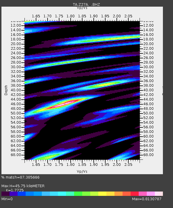
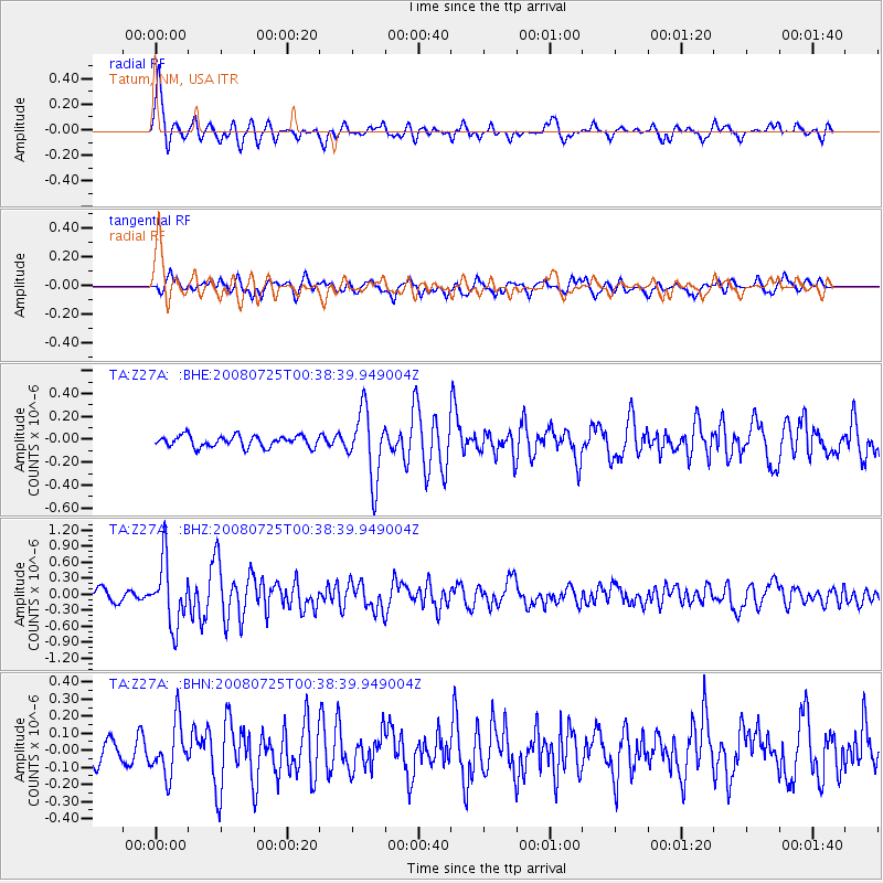
Z27A Tatum, NM, USA - Earthquake Result Viewer

Earthquake location: Rat Islands, Aleutian Islands
Earthquake latitude/longitude: 51.3/179.0
Earthquake time(UTC): 2008/07/25 (207) 00:29:22 GMT
Earthquake Depth: 21 km
Earthquake Magnitude: 5.7 MB, 5.5 MS, 5.9 MW, 5.9 MW
Earthquake Catalog/Contributor: WHDF/NEIC
Network: TA USArray Transportable Network (new EarthScope stations)
Station: Z27A Tatum, NM, USA
Lat/Lon: 33.31 N/103.21 W
Elevation: 1197 m
Distance: 57.6 deg
Az: 75.892 deg
Baz: 313.326 deg
Ray Param: 0.06339107
Estimated Moho Depth: 45.75 km
Estimated Crust Vp/Vs: 1.77
Assumed Crust Vp: 6.129 km/s
Estimated Crust Vs: 3.458 km/s
Estimated Crust Poisson's Ratio: 0.27
Radial Match: 87.385666 %
Radial Bump: 400
Transverse Match: 69.35651 %
Transverse Bump: 400
SOD ConfigId: 2504
Insert Time: 2010-03-06 20:46:43.491 +0000
GWidth: 2.5
Max Bumps: 400
Tol: 0.001

Signal To Noise

ChannelStoNSTALTA
TA:Z27A: :BHZ:20080725T00:38:39.949004Z6.08356435.957447E-79.792692E-8
TA:Z27A: :BHN:20080725T00:38:39.949004Z1.7578691.532845E-78.719905E-8
TA:Z27A: :BHE:20080725T00:38:39.949004Z6.0268482.9692907E-74.9267722E-8
Arrivals
Ps6.0 SECOND
PpPs20 SECOND
PsPs/PpSs26 SECOND