You are here: Home > Network List > TA - USArray Transportable Network (new EarthScope stations) Stations List
> Station Z27A Tatum, NM, USA > Earthquake Result Viewer
Z27A Tatum, NM, USA - Earthquake Result Viewer
| Earthquake location: |
Peru-Brazil Border Region |
| Earthquake latitude/longitude: |
-7.6/-74.4 |
| Earthquake time(UTC): |
2008/08/26 (239) 21:00:36 GMT |
| Earthquake Depth: |
154 km |
| Earthquake Magnitude: |
6.0 MB, 6.4 MW, 6.4 MW |
| Earthquake Catalog/Contributor: |
WHDF/NEIC |
|
| Network: |
TA USArray Transportable Network (new EarthScope stations) |
| Station: |
Z27A Tatum, NM, USA |
| Lat/Lon: |
33.31 N/103.21 W |
| Elevation: |
1197 m |
|
| Distance: |
49.1 deg |
| Az: |
327.696 deg |
| Baz: |
140.756 deg |
| Ray Param: |
0.06838762 |
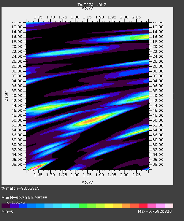
| Estimated Moho Depth: |
69.75 km |
| Estimated Crust Vp/Vs: |
1.63 |
| Assumed Crust Vp: |
6.129 km/s |
| Estimated Crust Vs: |
3.766 km/s |
| Estimated Crust Poisson's Ratio: |
0.20 |
|
| Radial Match: |
93.55315 % |
| Radial Bump: |
296 |
| Transverse Match: |
83.70841 % |
| Transverse Bump: |
400 |
| SOD ConfigId: |
2504 |
| Insert Time: |
2010-03-06 20:46:45.110 +0000 |
| GWidth: |
2.5 |
| Max Bumps: |
400 |
| Tol: |
0.001 |
|
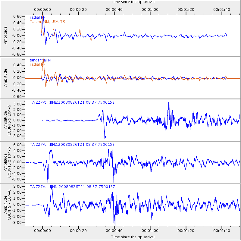
Signal To Noise
| Channel | StoN | STA | LTA |
| TA:Z27A: :BHZ:20080826T21:08:37.750015Z | 32.632893 | 2.7789545E-6 | 8.5158085E-8 |
| TA:Z27A: :BHN:20080826T21:08:37.750015Z | 10.276399 | 9.745593E-7 | 9.483471E-8 |
| TA:Z27A: :BHE:20080826T21:08:37.750015Z | 14.278614 | 1.0554714E-6 | 7.391974E-8 |
| Arrivals |
| Ps | 7.6 SECOND |
| PpPs | 28 SECOND |
| PsPs/PpSs | 36 SECOND |


