You are here: Home > Network List > TS - TERRAscope (Southern California Seismic Network) Stations List
> Station DGR Domenigoni Valley Reservior, California, USA > Earthquake Result Viewer
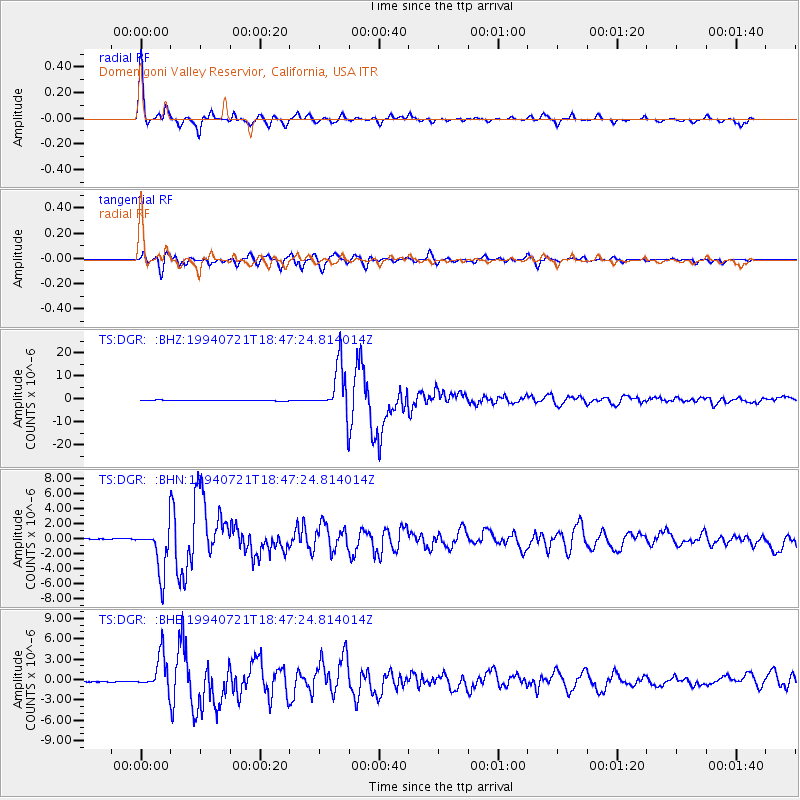
DGR Domenigoni Valley Reservior, California, USA - Earthquake Result Viewer

| Earthquake location: |
Primor'ye, Russia |
| Earthquake latitude/longitude: |
42.3/132.9 |
| Earthquake time(UTC): |
1994/07/21 (202) 18:36:31 GMT |
| Earthquake Depth: |
473 km |
| Earthquake Magnitude: |
6.4 MB, 7.2 UNKNOWN |
| Earthquake Catalog/Contributor: |
WHDF/NEIC |
|
| Network: |
TS TERRAscope (Southern California Seismic Network) |
| Station: |
DGR Domenigoni Valley Reservior, California, USA |
| Lat/Lon: |
33.65 N/117.01 W |
| Elevation: |
700 m |
|
| Distance: |
81.0 deg |
| Az: |
52.486 deg |
| Baz: |
315.134 deg |
| Ray Param: |
0.04655994 |
| Estimated Moho Depth: |
16.25 km |
| Estimated Crust Vp/Vs: |
1.93 |
| Assumed Crust Vp: |
6.264 km/s |
| Estimated Crust Vs: |
3.241 km/s |
| Estimated Crust Poisson's Ratio: |
0.32 |
|
| Radial Match: |
96.69431 % |
| Radial Bump: |
310 |
| Transverse Match: |
90.46463 % |
| Transverse Bump: |
400 |
| SOD ConfigId: |
16938 |
| Insert Time: |
2010-02-26 14:07:35.175 +0000 |
| GWidth: |
2.5 |
| Max Bumps: |
400 |
| Tol: |
0.001 |
|
Signal To Noise
| Channel | StoN | STA | LTA |
| TS:DGR: :BHN:19940721T18:47:24.814014Z | 50.429432 | 3.1560235E-6 | 6.258297E-8 |
| TS:DGR: :BHE:19940721T18:47:24.814014Z | 35.48626 | 2.5735128E-6 | 7.252139E-8 |
| TS:DGR: :BHZ:19940721T18:47:24.814014Z | 73.238594 | 1.0552608E-5 | 1.4408535E-7 |
| Arrivals |
| Ps | 2.5 SECOND |
| PpPs | 7.4 SECOND |
| PsPs/PpSs | 9.9 SECOND |


