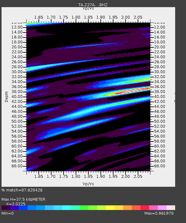
Z27A Tatum, NM, USA - Earthquake Result Viewer
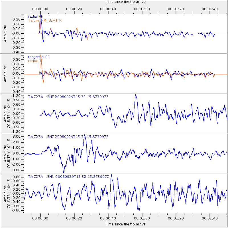
Earthquake location: Kermadec Islands, New Zealand
Earthquake latitude/longitude: -29.8/-177.7
Earthquake time(UTC): 2008/09/29 (273) 15:19:31 GMT
Earthquake Depth: 36 km
Earthquake Magnitude: 6.5 MB, 6.7 MS, 7.0 MW, 7.0 MW
Earthquake Catalog/Contributor: WHDF/NEIC
Network: TA USArray Transportable Network (new EarthScope stations)
Station: Z27A Tatum, NM, USA
Lat/Lon: 33.31 N/103.21 W
Elevation: 1197 m
Distance: 94.3 deg
Az: 54.003 deg
Baz: 237.16 deg
Ray Param: 0.041061174
Estimated Moho Depth: 37.5 km
Estimated Crust Vp/Vs: 2.02
Assumed Crust Vp: 6.129 km/s
Estimated Crust Vs: 3.03 km/s
Estimated Crust Poisson's Ratio: 0.34
Radial Match: 87.628426 %
Radial Bump: 400
Transverse Match: 71.29115 %
Transverse Bump: 400
SOD ConfigId: 2560
Insert Time: 2010-03-06 20:46:53.407 +0000
GWidth: 2.5
Max Bumps: 400
Tol: 0.001

Signal To Noise

ChannelStoNSTALTA
TA:Z27A: :BHZ:20080929T15:32:15.873997Z6.6215555.7813736E-78.731143E-8
TA:Z27A: :BHN:20080929T15:32:15.873997Z1.26329641.9592088E-71.5508702E-7
TA:Z27A: :BHE:20080929T15:32:15.873997Z2.1037122.618368E-71.2446418E-7
Arrivals
Ps6.4 SECOND
PpPs18 SECOND
PsPs/PpSs25 SECOND