You are here: Home > Network List > TA - USArray Transportable Network (new EarthScope stations) Stations List
> Station Z27A Tatum, NM, USA > Earthquake Result Viewer
Z27A Tatum, NM, USA - Earthquake Result Viewer
| Earthquake location: |
Kuril Islands |
| Earthquake latitude/longitude: |
48.3/154.2 |
| Earthquake time(UTC): |
2009/09/10 (253) 02:46:50 GMT |
| Earthquake Depth: |
36 km |
| Earthquake Magnitude: |
6.0 MB, 5.5 MS, 6.0 MW, 5.8 MW |
| Earthquake Catalog/Contributor: |
WHDF/NEIC |
|
| Network: |
TA USArray Transportable Network (new EarthScope stations) |
| Station: |
Z27A Tatum, NM, USA |
| Lat/Lon: |
33.31 N/103.21 W |
| Elevation: |
1197 m |
|
| Distance: |
73.4 deg |
| Az: |
58.497 deg |
| Baz: |
317.183 deg |
| Ray Param: |
0.05295394 |
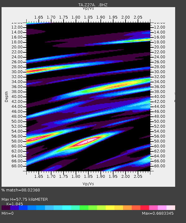
| Estimated Moho Depth: |
57.75 km |
| Estimated Crust Vp/Vs: |
1.85 |
| Assumed Crust Vp: |
6.129 km/s |
| Estimated Crust Vs: |
3.322 km/s |
| Estimated Crust Poisson's Ratio: |
0.29 |
|
| Radial Match: |
88.02368 % |
| Radial Bump: |
400 |
| Transverse Match: |
56.513626 % |
| Transverse Bump: |
373 |
| SOD ConfigId: |
2622 |
| Insert Time: |
2010-03-06 20:47:04.611 +0000 |
| GWidth: |
2.5 |
| Max Bumps: |
400 |
| Tol: |
0.001 |
|
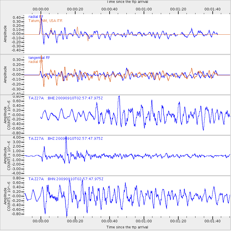
Signal To Noise
| Channel | StoN | STA | LTA |
| TA:Z27A: :BHZ:20090910T02:57:47.975Z | 5.685622 | 7.0141414E-7 | 1.2336629E-7 |
| TA:Z27A: :BHN:20090910T02:57:47.975Z | 2.753926 | 3.5292072E-7 | 1.2815185E-7 |
| TA:Z27A: :BHE:20090910T02:57:47.975Z | 1.783135 | 2.4201245E-7 | 1.3572301E-7 |
| Arrivals |
| Ps | 8.2 SECOND |
| PpPs | 26 SECOND |
| PsPs/PpSs | 34 SECOND |


