You are here: Home > Network List > TA - USArray Transportable Network (new EarthScope stations) Stations List
> Station Z27A Tatum, NM, USA > Earthquake Result Viewer
Z27A Tatum, NM, USA - Earthquake Result Viewer
| Earthquake location: |
Vanuatu Islands |
| Earthquake latitude/longitude: |
-13.0/166.5 |
| Earthquake time(UTC): |
2009/10/07 (280) 22:03:14 GMT |
| Earthquake Depth: |
45 km |
| Earthquake Magnitude: |
6.4 MB, 7.3 MS, 7.6 MW, 7.7 MW |
| Earthquake Catalog/Contributor: |
WHDF/NEIC |
|
| Network: |
TA USArray Transportable Network (new EarthScope stations) |
| Station: |
Z27A Tatum, NM, USA |
| Lat/Lon: |
33.31 N/103.21 W |
| Elevation: |
1197 m |
|
| Distance: |
97.2 deg |
| Az: |
57.574 deg |
| Baz: |
259.27 deg |
| Ray Param: |
0.04024436 |
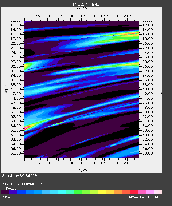
| Estimated Moho Depth: |
57.0 km |
| Estimated Crust Vp/Vs: |
1.60 |
| Assumed Crust Vp: |
6.129 km/s |
| Estimated Crust Vs: |
3.831 km/s |
| Estimated Crust Poisson's Ratio: |
0.18 |
|
| Radial Match: |
80.86409 % |
| Radial Bump: |
400 |
| Transverse Match: |
61.008274 % |
| Transverse Bump: |
400 |
| SOD ConfigId: |
2622 |
| Insert Time: |
2010-03-06 20:47:10.848 +0000 |
| GWidth: |
2.5 |
| Max Bumps: |
400 |
| Tol: |
0.001 |
|

Signal To Noise
| Channel | StoN | STA | LTA |
| TA:Z27A: :BHZ:20091007T22:16:11.024016Z | 6.425486 | 1.4434422E-6 | 2.2464327E-7 |
| TA:Z27A: :BHN:20091007T22:16:11.024016Z | 2.3003695 | 4.4511836E-7 | 1.9349864E-7 |
| TA:Z27A: :BHE:20091007T22:16:11.024016Z | 1.1038871 | 3.1376305E-7 | 2.8423474E-7 |
| Arrivals |
| Ps | 5.7 SECOND |
| PpPs | 24 SECOND |
| PsPs/PpSs | 29 SECOND |


