You are here: Home > Network List > TA - USArray Transportable Network (new EarthScope stations) Stations List
> Station Z27A Tatum, NM, USA > Earthquake Result Viewer
Z27A Tatum, NM, USA - Earthquake Result Viewer
| Earthquake location: |
Tonga Islands Region |
| Earthquake latitude/longitude: |
-23.0/-174.7 |
| Earthquake time(UTC): |
2009/03/19 (078) 18:17:40 GMT |
| Earthquake Depth: |
34 km |
| Earthquake Magnitude: |
7.0 MB, 7.6 MS, 7.6 MW, 7.6 MW |
| Earthquake Catalog/Contributor: |
WHDF/NEIC |
|
| Network: |
TA USArray Transportable Network (new EarthScope stations) |
| Station: |
Z27A Tatum, NM, USA |
| Lat/Lon: |
33.31 N/103.21 W |
| Elevation: |
1197 m |
|
| Distance: |
88.1 deg |
| Az: |
52.584 deg |
| Baz: |
240.893 deg |
| Ray Param: |
0.042772256 |
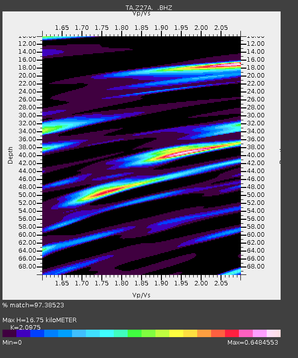
| Estimated Moho Depth: |
16.75 km |
| Estimated Crust Vp/Vs: |
2.10 |
| Assumed Crust Vp: |
6.129 km/s |
| Estimated Crust Vs: |
2.922 km/s |
| Estimated Crust Poisson's Ratio: |
0.35 |
|
| Radial Match: |
97.38523 % |
| Radial Bump: |
400 |
| Transverse Match: |
92.96949 % |
| Transverse Bump: |
400 |
| SOD ConfigId: |
2658 |
| Insert Time: |
2010-03-06 20:47:34.259 +0000 |
| GWidth: |
2.5 |
| Max Bumps: |
400 |
| Tol: |
0.001 |
|
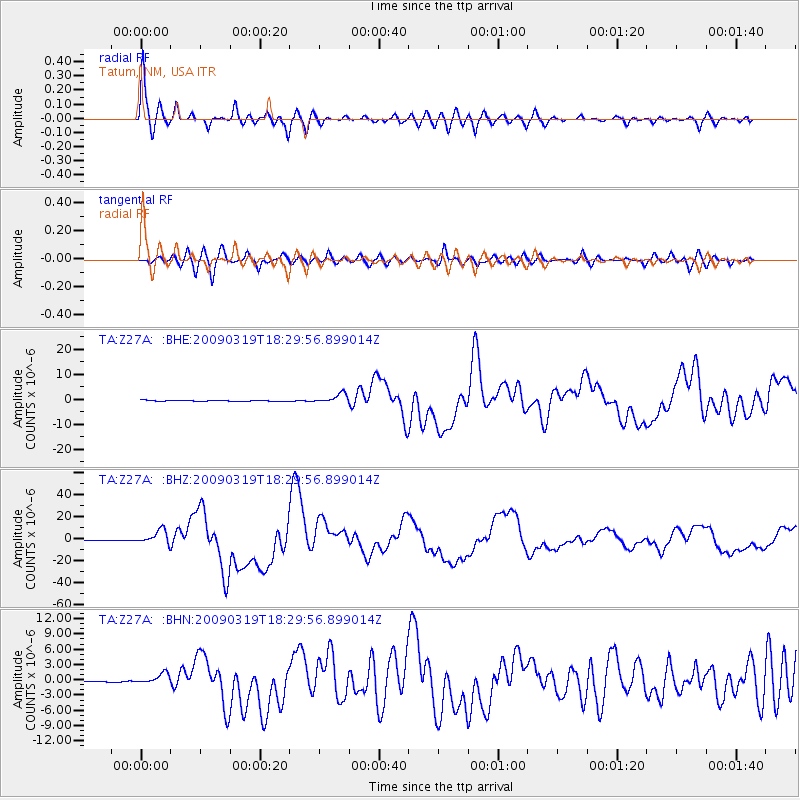
Signal To Noise
| Channel | StoN | STA | LTA |
| TA:Z27A: :BHZ:20090319T18:29:56.899014Z | 29.532333 | 6.50511E-6 | 2.2027078E-7 |
| TA:Z27A: :BHN:20090319T18:29:56.899014Z | 7.3115172 | 1.0666664E-6 | 1.4588852E-7 |
| TA:Z27A: :BHE:20090319T18:29:56.899014Z | 10.008889 | 1.9116471E-6 | 1.9099494E-7 |
| Arrivals |
| Ps | 3.1 SECOND |
| PpPs | 8.3 SECOND |
| PsPs/PpSs | 11 SECOND |


