You are here: Home > Network List > TA - USArray Transportable Network (new EarthScope stations) Stations List
> Station Z27A Tatum, NM, USA > Earthquake Result Viewer
Z27A Tatum, NM, USA - Earthquake Result Viewer
| Earthquake location: |
Kuril Islands |
| Earthquake latitude/longitude: |
46.0/151.4 |
| Earthquake time(UTC): |
2009/04/18 (108) 19:17:58 GMT |
| Earthquake Depth: |
35 km |
| Earthquake Magnitude: |
6.3 MB, 6.3 MS, 6.6 MW, 6.4 MW |
| Earthquake Catalog/Contributor: |
WHDF/NEIC |
|
| Network: |
TA USArray Transportable Network (new EarthScope stations) |
| Station: |
Z27A Tatum, NM, USA |
| Lat/Lon: |
33.31 N/103.21 W |
| Elevation: |
1197 m |
|
| Distance: |
76.3 deg |
| Az: |
56.226 deg |
| Baz: |
316.228 deg |
| Ray Param: |
0.051062495 |
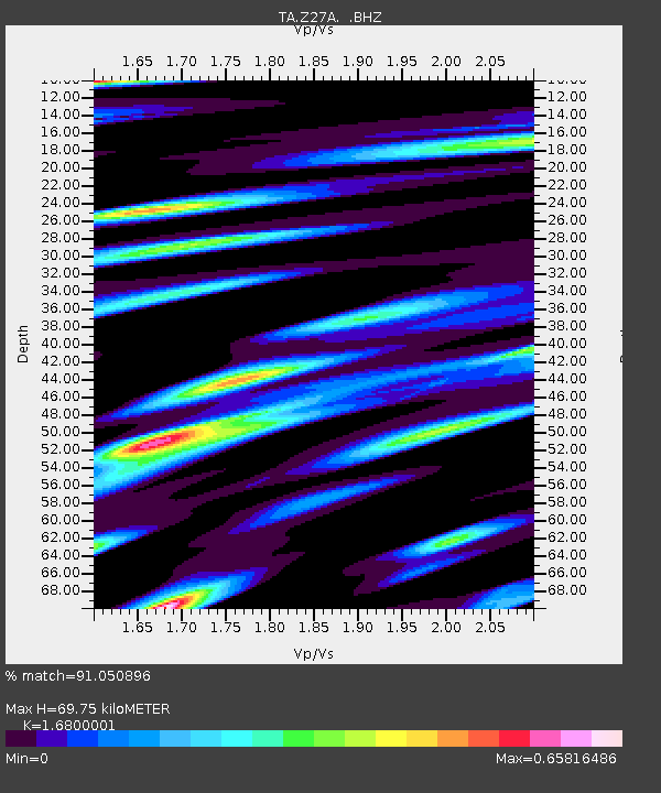
| Estimated Moho Depth: |
69.75 km |
| Estimated Crust Vp/Vs: |
1.68 |
| Assumed Crust Vp: |
6.129 km/s |
| Estimated Crust Vs: |
3.648 km/s |
| Estimated Crust Poisson's Ratio: |
0.23 |
|
| Radial Match: |
91.050896 % |
| Radial Bump: |
400 |
| Transverse Match: |
84.66381 % |
| Transverse Bump: |
400 |
| SOD ConfigId: |
2760 |
| Insert Time: |
2010-03-06 20:47:44.492 +0000 |
| GWidth: |
2.5 |
| Max Bumps: |
400 |
| Tol: |
0.001 |
|
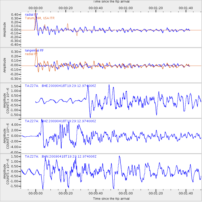
Signal To Noise
| Channel | StoN | STA | LTA |
| TA:Z27A: :BHZ:20090418T19:29:12.974006Z | 22.749334 | 2.4813303E-6 | 1.0907265E-7 |
| TA:Z27A: :BHN:20090418T19:29:12.974006Z | 4.4048686 | 5.445975E-7 | 1.2363537E-7 |
| TA:Z27A: :BHE:20090418T19:29:12.974006Z | 3.375223 | 4.892332E-7 | 1.449484E-7 |
| Arrivals |
| Ps | 8.0 SECOND |
| PpPs | 30 SECOND |
| PsPs/PpSs | 38 SECOND |


