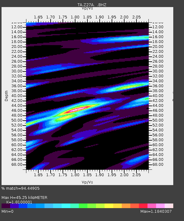
Z27A Tatum, NM, USA - Earthquake Result Viewer
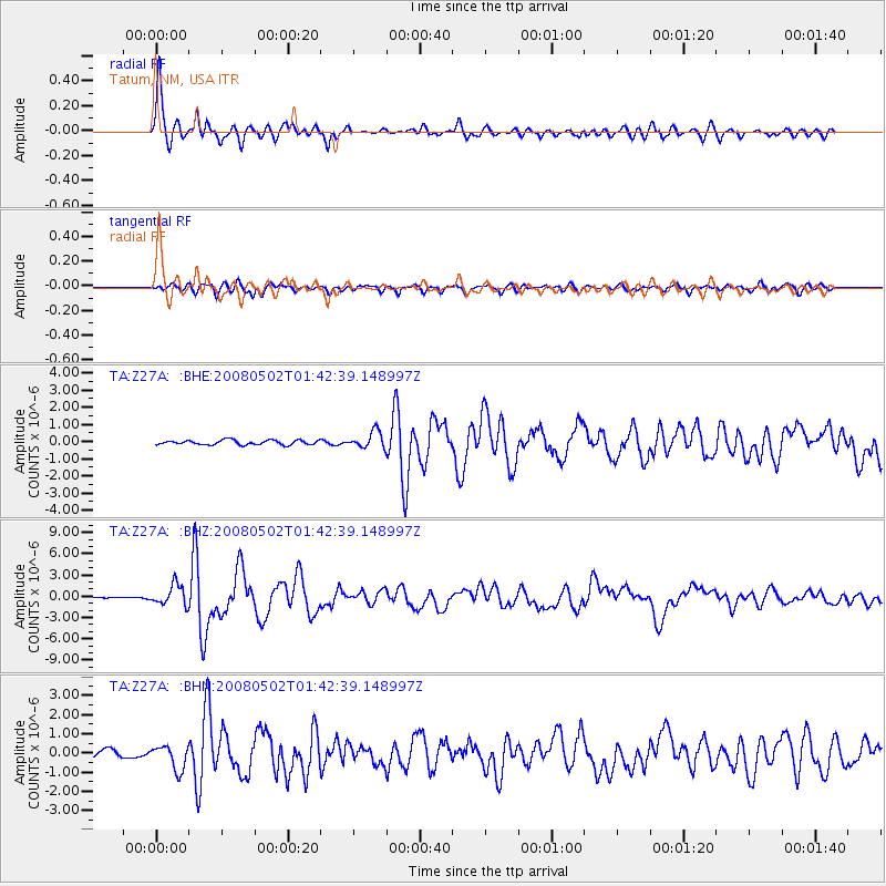
Earthquake location: Andreanof Islands, Aleutian Is.
Earthquake latitude/longitude: 51.9/-177.5
Earthquake time(UTC): 2008/05/02 (123) 01:33:37 GMT
Earthquake Depth: 14 km
Earthquake Magnitude: 6.3 MB, 6.8 MS, 6.6 MW, 6.6 MW
Earthquake Catalog/Contributor: WHDF/NEIC
Network: TA USArray Transportable Network (new EarthScope stations)
Station: Z27A Tatum, NM, USA
Lat/Lon: 33.31 N/103.21 W
Elevation: 1197 m
Distance: 55.3 deg
Az: 78.681 deg
Baz: 313.436 deg
Ray Param: 0.06487291
Estimated Moho Depth: 45.25 km
Estimated Crust Vp/Vs: 1.81
Assumed Crust Vp: 6.129 km/s
Estimated Crust Vs: 3.386 km/s
Estimated Crust Poisson's Ratio: 0.28
Radial Match: 94.44905 %
Radial Bump: 323
Transverse Match: 81.93401 %
Transverse Bump: 400
SOD ConfigId: 2504
Insert Time: 2010-03-06 20:47:50.209 +0000
GWidth: 2.5
Max Bumps: 400
Tol: 0.001

Signal To Noise

ChannelStoNSTALTA
TA:Z27A: :BHZ:20080502T01:42:39.148997Z12.3239031.457071E-61.18231284E-7
TA:Z27A: :BHN:20080502T01:42:39.148997Z4.67776.372458E-71.3623058E-7
TA:Z27A: :BHE:20080502T01:42:39.148997Z3.69593524.8670626E-71.316869E-7
Arrivals
Ps6.3 SECOND
PpPs20 SECOND
PsPs/PpSs26 SECOND